Ramanathapura, Hassan

Ramanathapura
village
Ramanathapura
Ramanathapura
Map
Coordinates: 12°36′57″N 76°04′46″E / 12.61576°N 76.07932°E / 12.61576; 76.07932
Country India
StateKarnataka
DistrictHassan
TalukArkalgud
Elevation
849 m (2,785 ft)
Population
 (2011)
 • Total
1,578
Languages
 • OfficialKannada
Time zoneUTC+5:30 (IST)

Rāmanāthapura is a village in Hassan district of Karnataka state, India.
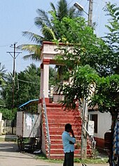
Subramanyia Temple area

Location

Ramanathapura is located between Konanur and Saligrama towns.

Administration

Ramanathapura is part of the Arkalgud taluk which is again part of Hassan district of Karnataka.

Post office

There is a post office at Ramanathapura and the postal code is 573133.[1]

Educational organizations

  • HMS Padavi Purva College
  • BSS Junior College
  • Kuvempu School
  • JSP School
  • GHP School

See also

References

  1. ^ "Ramanathapura, Hassan District Pincode 573133". Archived from the original on 18 October 2016. Retrieved 16 October 2016.