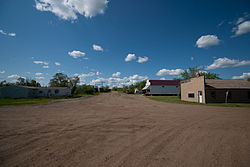
Census-designated place in North Dakota, United States
Raleigh is a census-designated place (CDP) in Grant County , North Dakota , United States. An unincorporated community , it was designated as part of the U.S. Census Bureau 's Participant Statistical Areas Program on March 31, 2010.[ 3] 2000 Census ,[ 4] 2010 Census ,[ 5] [ 6]
Geography
It is located in the northeast quarter of section 12 of Township 133 north, Range 86 west.[ 7] Dogtooth , a nearby town and post office which soon afterward ceased to exist.[ 7]
Demographics
Historical population
Census Pop. Note %± 2020 14 —
History
Raleigh is situated in what was originally Morton County but today is Grant County. Raleigh was created as a coaling stop along the Milwaukee Road branch line that separated from the railroad's Pacific Extension in McLaughlin, South Dakota and ran to New England, North Dakota . The name comes from Sir Walter Raleigh and was settled by a wave of German Russians who had previously settled near Strasburg in Emmons County .[ 7]
References
^ "ArcGIS REST Services Directory" . United States Census Bureau. Retrieved September 20, 2022 .^ a b U.S. Geological Survey Geographic Names Information System: Raleigh, North Dakota ^ "Raleigh Census Designated Place" . Geographic Names Information System United States Geological Survey , United States Department of the Interior .^ U.S. Census Bureau (2003). "Population and Housing Unit Counts, North Dakota" (PDF) . 2000 Census of Population and Housing . Government Printing Office . Retrieved July 20, 2008 .^ U.S. Census Bureau (February 13, 2008). "Census Designated Place (CDP) Program for the 2010 Census—Final Criteria" (PDF) . Federal Register the original (PDF) on October 18, 2010. Retrieved July 13, 2010 .^ "2010 Census Redistricting Data (Public Law 94-171) Summary File" . American FactFinder . United States Census Bureau . Retrieved May 2, 2011 .[dead link ] ^ a b c Wick, Douglas A. (1988). North Dakota Place Names . Bismarck, North Dakota : Hedemarken Collectibles. ISBN 0-9620968-0-6 OCLC 191277027 . ^ "Census of Population and Housing" . Census.gov. Retrieved June 4, 2016 .
46°21′28″N 101°18′24″W / 46.357781°N 101.306528°W / 46.357781; -101.306528
Counties Core cities Surrounding areas


