|
Planá (Tachov District)
Planá (also known as Planá u Mariánských Lázní; Czech pronunciation: [ˈplanaː]; German: Plan) is a town in Tachov District in the Plzeň Region of the Czech Republic. It has about 5,700 inhabitants. The historic town centre is well preserved and is protected by law as an urban monument zone. Administrative partsThe villages of Křínov, Kříženec, Otín, Pavlovice, Svahy, Týnec, Vížka, Vysoké Sedliště and Zliv are administrative parts of Planá. EtymologyThe word planá meant 'barren', but it also denoted a wide, open landscape.[2] GeographyPlaná is located about 10 kilometres (6 mi) northeast of Tachov and 46 km (29 mi) west of Plzeň. It lies on the border between the Teplá Highlands and Upper Palatine Forest Foothills. The highest point is the hill Homole at 681 m (2,234 ft) above sea level. The Mže River flows through the southern part of the municipal territory. The stream Kosový potok flows along the eastern municipal border and then joins the Mže. The stream Hamerský potok flows through the western part of the municipal territory. The brook Planský potok, its tributary, flows next to the town centre. There are several fishponds in the territory of Planá; the largest of them are Anenský and Labutí. HistoryThe first written mention of Planá is from 1251. Planá was located on an important trade route from Nuremberg to Cheb. The oldest part of Planá was built during the 13th and 14th century and at the end of the 14th century it was quite a large town, surrounded by walls and a moat.[3] In the 16th century, two plague epidemics hit the town, which caused a significant decrease in the population and led to the invitation of colonists from Germany and the beginning of the Germanization of the town. Another misfortune came in the 17th century during the Thirty Years' War, when Planá was conquered and looted several times by various armies.[3] The Planá estate was owned by several aristocratic families, including Lords of Dobrohošť, Žeberka family, Schlick family, Sinzerdorf family, Nostitz family and Nostitz-Rhieneck family. The most significant owners were the Schlick family. During their reign, mining flourished and the mint was moved to Planá after it ceased to exist in Jáchymov.[3] Demographics
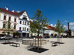
Transport The I/21 road, which connects the D5 motorway with Cheb, passes through the town. Planá is located on the railway line Plzeň–Karlovy Vary.[6] Sights The Svobody Square is in the town's historic core. The town hall was built in 1680–1685. The Baroque plague column with the statue of Saint John of Nepomuk on its top is from 1712. Most of the houses on the square are in Gothic or Renaissance style and are protected as cultural monuments.[7] The oldest town's monument is the Church of Saints Peter and Paul from the 13th century. It is the nationwide important monument with unique frescoes and a rare Romanesque portal with an arched frieze.[7] The Church of the Assumption of the Virgin Mary is the largest church in Planá. It was built in the 13th–14th century, originally in the late Romanesque style.[7] The Mining Museum is located in the Ondřej Schlick adit, which was excavated in the 16th century. It documents mining of silver ore in Planá and its surroundings, and existence of mint for minting silver coins, owned the Schlick family.[7] The castle was continuously built and rebuilt from the 13th to the 20th century and therefore contains building elements from Gothic to the present. Between 1948 and 1991 it served as barracks of the border guard and since then it is abandoned and is crumbling. Its English park is open to the public.[7] Notable people
Twin towns – sister cities
References
External linksWikimedia Commons has media related to Planá (Tachov District). |
||||||||||||||||||||||||||||||||||||||||||||||||||||||||||||||||||||||||||||||||||||||||||||||||||||||||


