Pine Grove, Schuylkill County, Pennsylvania

Pine Grove, Pennsylvania
Borough
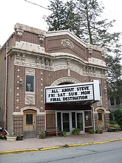
Pine Grove Theatre, which opened in Pine Grove in 1910 and closed in 2019
Location of Pine Grove in Schuylkill County, Pennsylvania
Pine Grove is located in Pennsylvania
Pine Grove
Pine Grove
Location of Pine Grove in Pennsylvania
Pine Grove is located in the United States
Pine Grove
Pine Grove
Pine Grove (the United States)
Coordinates: 40°33′04″N 76°23′06″W / 40.55111°N 76.38500°W / 40.55111; -76.38500
CountryUnited States
StatePennsylvania
CountySchuylkill
Settled1830
Incorporated1832
Government
 • TypeBorough Council
 • MayorRowan Medcraft
Area
 • Total
1.06 sq mi (2.76 km2)
 • Land1.06 sq mi (2.76 km2)
 • Water0.00 sq mi (0.00 km2)
Population
 • Total
2,049
 • Density1,923.94/sq mi (743.10/km2)
Time zoneUTC-5 (Eastern (EST))
 • Summer (DST)UTC-4 (EDT)
ZIP code
17963
Area code570
FIPS code42-60456
GNIS feature ID1215563

Pine Grove is a borough in Schuylkill County, Pennsylvania, United States. As of the 2020 census, the borough population was 2,054.[3]

Pine Grove Area School District, serving students from three municipalities and multiple surrounding townships, is located in the borough.

History

Pine Grove was officially incorporated in 1832.[4]

European settlement of the area by German Palatines, however, pre-dates this official founding date by at least several decades. Historical records document the Jacob Gunkle building was Lutheran church in the area as early as 1782.[5]

The historic Nutting Hall was built between 1823 and 1825.[6] Both Nutting Hall and the surrounding Pine Grove Historic District are listed on the National Register of Historic Places.[7]

The 335-seat Pine Grove Theatre, which is also part of the Pine Grove Historic District, opened in 1910 and is still up and running {2021}.[8]

Geography

Swatara Creek, a tributary of the Susquehanna River, runs through Pine Grove.[4][9]

A 22-mile (35 km) feeder branch of the Union Canal connected the Swatara Creek at Pine Grove to Union Water Works between 1830 (or 1832) and 1862, until its destruction when the Swatara flooded in June 1862. The branch canal was used to ship anthracite[8] and supply water to the Water Works. Parts of Swatara State Park are located along the Swatara Creek within Pine Grove.

Demographics

Historical population
CensusPop.Note
1850646
1870845
188095713.3%
18901,10315.3%
19001,084−1.7%
19101,35224.7%
19201,77831.5%
19302,25726.9%
19402,239−0.8%
19502,237−0.1%
19602,2671.3%
19702,197−3.1%
19802,2442.1%
19902,118−5.6%
20002,1541.7%
20102,1861.5%
20202,054−6.0%
2021 (est.)2,057[3]0.1%
Sources:[10][11][12]

At the 2000 census, there were 2,154 people,877 households, and 558 families residing in the borough. The population density was 1,997.0 inhabitants per square mile (771.0/km2). There were 937 housing units at an average density of 868.7 per square mile (335.4/km2). The racial makeup of the borough was 98.75% White, 0.14% African American, 0.00% Native American, 0.51% Asian, 0.00% Pacific Islander, 0.09% from other races, and 0.51% from two or more races. 0.05% of the population were Hispanic or Latino of any race.

Of the 877 households, 27.6% had children under the age of 18 living with them, 50.4% were married couples living together, 9.7% had a female householder with no husband present, and 36.3% were non-families. 30.9% of households were one person, and 17.7% were one person aged 65 or older. The average household size was 2.36 and the average family size was 2.98.

In Pine Grove, the population was spread out, with 21.9% under the age of 18, 7.9% from 18 to 24, 28.6% from 25 to 44, 22.6% from 45 to 64, and 19.1% 65 or older. The median age was 39 years. For every 100 females there were 89.3 males. For every 100 females age 18 and over, there were 87.4 males.

The median household income was $35,865 and the median family income was $49,737. Males had a median income of $31,369 versus $21,818 for females. The per capita income for the borough was $19,547. 5.9% of the population and 2.6% of families were below the poverty line. Out of the total people living in poverty, 2.9% are under the age of 18 and 5.6% are 65 or older.

Education

The school district is Pine Grove Area School District.[13]

Notable people

References

  1. ^ "ArcGIS REST Services Directory". United States Census Bureau. Retrieved October 16, 2022.
  2. ^ "Census Population API". United States Census Bureau. Retrieved Oct 12, 2022.
  3. ^ a b Bureau, US Census. "City and Town Population Totals: 2020—2021". Census.gov. US Census Bureau. Retrieved August 1, 2022. {{cite web}}: |last1= has generic name (help)
  4. ^ a b "About Us - Pine Grove Borough". pinegroveborough.org. 2020. Retrieved 17 September 2020.
  5. ^ "200 Years at Saint Peter's: Celebrating God's for All Creation." Pine Grove, Pennsylvania: Saint Peter's Church, retrieved online August 23, 2019.
  6. ^ "National Historic Landmarks & National Register of Historic Places in Pennsylvania" (Searchable database). CRGIS: Cultural Resources Geographic Information System. Note: This includes Margery Wheeler Mattox (n.d.). "National Register of Historic Places Inventory Nomination Form: Nutting Hall" (PDF). Retrieved 2012-06-02.
  7. ^ "National Register Information System". National Register of Historic Places. National Park Service. July 9, 2010.
  8. ^ a b "National Historic Landmarks & National Register of Historic Places in Pennsylvania" (Searchable database). CRGIS: Cultural Resources Geographic Information System. Note: This includes Gabrielle Ramsauer and William Sisson (1987). "National Register of Historic Places Inventory Nomination Form: Pine Grove Historic District" (PDF). Retrieved 2012-06-02.
  9. ^ Zerbe, Leah (January 4, 2021). "New wetland gives Pine Grove gift of dry basements". Pottsville Republican Herald. Retrieved 2021-01-05.
  10. ^ "Census of Population and Housing". U.S. Census Bureau. Retrieved 11 December 2013.
  11. ^ "U.S. Census website". United States Census Bureau. Retrieved 2008-01-31.
  12. ^ "Incorporated Places and Minor Civil Divisions Datasets: Subcounty Resident Population Estimates: April 1, 2010 to July 1, 2012". Population Estimates. U.S. Census Bureau. Archived from the original on June 11, 2013. Retrieved 11 December 2013.
  13. ^ "2020 CENSUS - SCHOOL DISTRICT REFERENCE MAP: Schuylkill County, PA" (PDF). U.S. Census Bureau. Retrieved 2024-12-14. - Text list
  14. ^ "Richard 'Dick' Wheeler" (obituary). Pottsville, Pennsylvania: Republican & Herald, October 27, 2008 (retrieved online via Legacy.com, August 24, 2019).
  15. ^ Moskin, J. Robert. "To the Sound of Iwo Jima." Washington, D.C.: The Washington Post, December 18, 1983.