|
Pepys Island
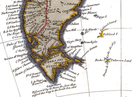
Pepys Island /ˈpiːps/ is a phantom island, once said to lie about 230 nautical miles (260 mi; 430 km) north of the Falkland Islands at 47°S.[1] Pepys Island is now believed to have been a misidentified account of the Falkland Islands. Original identificationIn December 1683 the British corsair William Ambrose Cowle(y), master of the Bachelor's Delight, a ship of 40 guns proceeding on a circumnavigation of the globe, discovered at a latitude stated as 47°S a previously uncharted and unpopulated island in the South Atlantic which he named "Pepys Island", for Samuel Pepys, Secretary to the Admiralty. His companion on the voyage, William Dampier, considered the sighting to be the "Sebaldinas Islands", an alternative name at the time for the Falklands. Cowle's log entry reads:[2]: 34
There is a later manuscript elaborating the log entry:
Later attempts to locate the islandThe original official historian of record,[2]: 35 Pedro de Angelis, wrote in 1839 that this was so far north of the Falklands it was "absurd" to think that an experienced navigator could have made such an error as to put himself four degrees of latitude more northerly, and in high summer. Many expeditions attempted unsuccessfully to locate the island during the eighteenth century. These included: Lord Anson (1740–1744 voyage), Commodore Byron (1764), Captain Cook (both voyages), Joseph Banks and Daniel Solander (1769), Antoine-Joseph Pernety (1763–1764), Louis de Bougainville (1763-1769 voyages), Jean-François de Galaup, comte de Lapérouse (1785, searching for "The Great Island") and George Vancouver (1790-1795 voyages, also searching for "The Great Island"). In the reports of Byron, Cook and Bougainville[2]: 39 all found themselves in thick sargasso with large flocks of birds overhead. They were searching 80 to 85 leagues both east of the Patagonian coast and north of the Falklands (from 1630–1840 a Spanish league measured three nautical miles) and these may be considered sure signs of the proximity of land. La Pérouse mentioned the seaweed and identified the flocks of birds as albatross and petrels which never approach land except to lay their eggs. In conclusion to his 1839 introduction to the work of reference, Pedro de Angelis noted that the report of a mercantile master returning to Montevideo from the Falklands came to the attention of the Spanish Minister, who consulted with Don Jorge Juan, head of the Department of the Navy. They identified Pepys Island as being synonymous with Puig, a phantom island sought by the French and known as "the Great Island". This was based on three documents: Cowle's sketch, Puig Island as sketched by the mercantile captain and a plan "of unimpeachable provenance" which he does not name. De Angelis concluded: "In view of the explicit statements made by those who have actually visited the island, those who deny its existence lack authenticity." The modern editor of the work of reference, Professor Pesatti, dissents[2]: 42 from Pedro de Angelis, particularly on the basis of Cowle's sketch, a document which unfortunately he fails to produce in evidence: "The description of the island coincides in almost all details to the Falklands, and a sketch map by Cowle represents exactly the alignment of these islands with the central strait which divides them." See alsoNotes
References
|
||||||||
