Nurdağı

Nurdağı
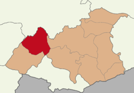
Map showing Nurdağı District in Gaziantep Province
Nurdağı is located in Turkey
Nurdağı
Nurdağı
Location in Turkey
Coordinates: 37°10′44″N 36°44′23″E / 37.17889°N 36.73972°E / 37.17889; 36.73972
CountryTurkey
ProvinceGaziantep
Government
 • MayorYakup Bahar (AKP)
Area
697 km2 (269 sq mi)
Population
 (2022)[1]
41,322
 • Density59/km2 (150/sq mi)
Time zoneUTC+3 (TRT)
Postal code
27840
Area code0342
Websitewww.nurdagi.bel.tr

Nurdağı (pronounced [nuɾˈdaˈɯ]) is a municipality and district of Gaziantep Province, Turkey.[2] Its area is 697 km2,[3] and its population is 41,322 (2022).[1] Nurdağı is 45 kilometres (28 mi) west of the city of Gaziantep.

A magnitude 7.8 earthquake struck 6 kilometres (3.7 mi) from Nurdağı on 6 February 2023, causing widespread devastation in the district and around 2,500 deaths.[4][5] Mass graves were created to bury the overwhelming number of dead in the area.[6]

Composition

There are 48 neighbourhoods in Nurdağı District:[7]

References

  1. ^ a b "Address-based population registration system (ADNKS) results dated 31 December 2022, Favorite Reports" (XLS). TÜİK. Retrieved 12 July 2023.
  2. ^ Büyükşehir İlçe Belediyesi, Turkey Civil Administration Departments Inventory. Retrieved 12 July 2023.
  3. ^ "İl ve İlçe Yüz ölçümleri". General Directorate of Mapping. Retrieved 12 July 2023.
  4. ^ "Nurdağı'ndaki hasar havadan görüntülendi" (in Turkish). TRT Haber. 2023-02-08.
  5. ^ "Gaziantep'in Nurdağı ilçesinde arama kurtarma çalışmaları" (in Turkish). Anadolu Agency. 2023-02-15.
  6. ^ Tondo, L.; Narlı, D. B.; Michaelson, R.; Hezaber, H. (10 February 2023). "No room for the dead as cemeteries in earthquake-hit Turkey and Syria fill up". The Guardian. Retrieved 10 February 2023.
  7. ^ Mahalle, Turkey Civil Administration Departments Inventory. Retrieved 12 July 2023.