Nantoa

Nantoa
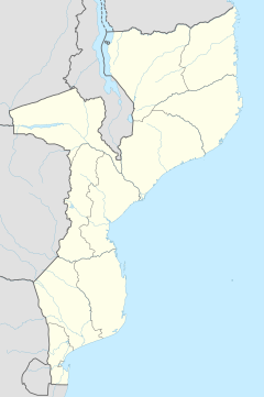
Nantoa is located in Mozambique
Nantoa
Nantoa
Location in Mozambique
Coordinates: 12°54′52″S 39°28′46″E / 12.91444°S 39.47944°E / -12.91444; 39.47944
Country Mozambique
ProvinceCabo Delgado Province
DistrictAncuabe District
Time zoneUTC+2 (Central Africa Time)

Nantoa is a village in Ancuabe District in Cabo Delgado Province in northeastern Mozambique.[1]

Coordinates

UTM : EF57. Geographical coordinates in decimal degrees (WGS84) at latitude -12.914 and longitude 39.479. Geographical coordinates in degrees minutes seconds (WGS84) at latitude -12 54' 52 and longitude 39 28' 46. [2]

Daylight duration

In the Nantoa village, Sunrise is by 05:02:56 and Sunset is by 17:18:24. [3]

Places near Nantoa

Assane, Cauo, Chefe chinande, Chitima, Insania, Iupuro, Maon-o, Mapia, Megama, Mepoto, Muaja, Muepurra, Mussa, Namaica - Namarro. [4]

References

  1. ^ "NGA GeoName Database". National Geospatial-Intelligence Agency. Archived from the original on 2008-06-08. Retrieved 2008-06-26.
  2. ^ "NANTOA Geography Population Map cities coordinates location - Tageo.com". www.tageo.com. Retrieved 2024-10-04.
  3. ^ "NANTOA Geography Population Map cities coordinates location - Tageo.com". www.tageo.com. Retrieved 2024-10-04.
  4. ^ "NANTOA Geography Population Map cities coordinates location - Tageo.com". www.tageo.com. Retrieved 2024-10-04.