Nachrodt-Wiblingwerde

Nachrodt-Wiblingwerde
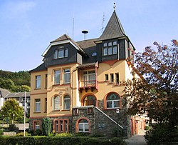
Old town hall (Amtshaus)
Coat of arms of Nachrodt-Wiblingwerde
Location of Nachrodt-Wiblingwerde within Märkischer Kreis district
Märkischer KreisNorth Rhine-WestphaliaOberbergischer KreisEnnepe-Ruhr-KreisHagenDortmundUnna (district)Soest (district)HochsauerlandkreisOlpe (district)AltenaMeinerzhagenNeuenradeKierspeHalverHerscheidMendenNachrodt-WiblingwerdePlettenbergSchalksmühleHemerLüdenscheidIserlohnBalveWerdohl
Nachrodt-Wiblingwerde is located in Germany
Nachrodt-Wiblingwerde
Nachrodt-Wiblingwerde is located in North Rhine-Westphalia
Nachrodt-Wiblingwerde
Coordinates: 51°19′N 07°39′E / 51.317°N 7.650°E / 51.317; 7.650
CountryGermany
StateNorth Rhine-Westphalia
Admin. regionArnsberg
DistrictMärkischer Kreis
Subdivisions7
Government
 • Mayor (2018–23) Birgit Tupat[1] (Ind.)
Area
 • Total
29.01 km2 (11.20 sq mi)
Elevation
305 m (1,001 ft)
Population
 (2023-12-31)[2]
 • Total
6,418
 • Density220/km2 (570/sq mi)
Time zoneUTC+01:00 (CET)
 • Summer (DST)UTC+02:00 (CEST)
Postal codes
58769
Dialling codes02352 u. 02334
Vehicle registrationMK
Websitewww.nachrodt-wiblingwerde.de

Nachrodt-Wiblingwerde is a municipality in the Märkischer Kreis, North Rhine-Westphalia, Germany.

Geography

The municipality is split into two main settlements. Nachrodt is located in the valley of the river Lenne at an altitude of 140 m above sea level, while Wiblingwerde is located at an altitude of 480 m on the hills of the Lennegebirge, one of the hill chains in the Sauerland mountains.

Division of the municipality

  • Nachrodt:
    • Obstfeld
    • Einsal
    • Opperhusen
    • Holensiepen
  • Wiblingwerde:
    • Veserde
    • Rennerde
    • Brenscheid
    • Sassenscheid
    • Eilerde
    • Herlsen
    • Wörden
    • Kaltenborn

History

The municipality was formed in 1907, when the Amt Altena was dissolved. The two municipalities Kelleramt and Wiblingwerde were merged into the new municipality Nachrodt-Wiblingwerde, which was no longer member in an Amt anymore.

Coat of arms

The coat of arms of the municipality shows in the top part the red and silver rose from the church seal of the Kirchspiel Wiblingwerde. In the bottom is a wavy line representing the river Lenne and thus Nachrodt. Both symbols are separated by the red-and-silver chequered bar of the Mark. The coat of arms was designed by Otto Hupp, and was granted on October 17, 1935.

References

  1. ^ Bürgermeisterwahl Gemeinde Nachrodt-Wiblingwerde, accessed 21 June 2021.
  2. ^ "Bevölkerung der Gemeinden Nordrhein-Westfalens am 31. Dezember 2023 – Fortschreibung des Bevölkerungsstandes auf Basis des Zensus vom 9. Mai 2011" (in German). Landesbetrieb Information und Technik NRW. Retrieved 2024-06-20.

Media related to Nachrodt-Wiblingwerde at Wikimedia Commons