|
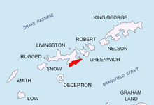
Levski Ridge    Levski Ridge (Bulgarian: Хребет Левски \'hre-bet 'lev-ski\) is the central ridge of the Tangra Mountains, Livingston Island. Its summit, Great Needle Peak rises to 1,680m and is the second highest summit of the island after Mount Friesland.[1] The ridge extends nearly 8 km between Shipka Saddle to the west and Devin Saddle to the east, and the same distance between Cherepish Ridge to the north and Christoff Cliff to the south. It is bounded by Huron Glacier to the north, Iskar Glacier to the northeast, Macy Glacier and Boyana Glacier to the southwest, and Srebarna Glacier and Magura Glacier to the southeast. The ridge takes its name from Levski Peak. Remark: The name form ‘Great Needle’ has become established in usage for the ridge's summit, with ‘great’ considered more appropriate than the adjective ‘false’ in its Spanish name form ‘Pico Falsa Aguja’ as this major peak is hardly associated with the ‘true’ Needle Peak (Pico Aguja), a sharp black peak of elevation just 370 m situated near Samuel Point 8 km away. LocationThe midpoint is located at 62°39′45″S 60°03′00″W / 62.66250°S 60.05000°W which is situated 6.84 km east of Mount Friesland, 6.8 km southeast of Kuzman Knoll, 6.75 km west-southwest of Delchev Peak, and 3.3 km northwest of M'Kean Point (British mapping in 1968, Argentine mapping in 1980, and Bulgarian mapping in 2005 and 2009 from the topographic survey Tangra 2004/05). Maps
Notes
References
External links
This article includes information from the Antarctic Place-names Commission of Bulgaria which is used with permission. |