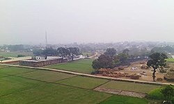
Kusi, Dildarnagar

Kusi
Azamabad
village
Aerial view of the village Kusi, winter 2015
Nickname: 
Cleanest village of Ghazipur
Kusi is located in Uttar Pradesh
Kusi
Kusi
Location in Uttar Pradesh, India
Coordinates: 25°24′33″N 83°38′05″E / 25.409167°N 83.634839°E / 25.409167; 83.634839
Country India
StateUttar Pradesh
DistrictGhazipur
Established1610; 415 years ago (1610)
Founded byZamindar Azam Khan
Government
 • BodyGram Panchayat
Area
 • Total
436.91 ha (1,079.63 acres)
 • Land428.822 ha (1,059.642 acres)
 • Water8.088 ha (19.986 acres)
Population
 (2011)
 • Total
5,710
 • Density1,300/km2 (3,400/sq mi)
DemonymKamsari
Local language Bhojpuri
 • OfficialHindi Urdu
Time zoneUTC+5:30 (IST)
Vehicle registrationUP
Websiteup.gov.in

Kusi (formerly also called Azmabad) is a village of Kamsaar in Ghazipur district in the Indian state of Uttar Pradesh. The village has also Jama masjid Kusi.[clarification needed] The nearest railway station is Dildar nagar. As of 2011 census the main population of the village lived in an area of 62 acres and had 796 households. .[1][2] The village was Azam Khan a great grandson of Raja Narhar Khan.

Ancestry of Kamsar Pathans.

Historical population

Population Growth of Kusi
YearPop.±%
18612,550—    
18712,863+12.3%
18813,024+5.6%
18913,156+4.4%
19013,205+1.6%
19113,280+2.3%
19213,300+0.6%
19313,525+6.8%
19413,650+3.5%
19513,200−12.3%
19612,980−6.9%
19713,378+13.4%
19813,905+15.6%
19914,966+27.2%
20015,463+10.0%
20115,710+4.5%
Source:Census of India[3][4][5]

References

  1. ^ "Bhulekh".
  2. ^ "2011 census of India".
  3. ^ "Census of India". mospi.gov.in. Archived from the original on 13 August 2008. Retrieved 23 June 2008.
  4. ^ "2011 census of India".
  5. ^ "Historical Census of India". Archived from the original on 17 February 2013. Retrieved 5 November 2015.