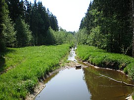
Krakės-Dotnuva Forest

Krakės-Dotnuva Forest
Lithuanian: Krakių-Dotnuvos miškai
The Jaugila river running through the forest
Map
Map showing the location of Krakės-Dotnuva Forest
Geography
LocationKėdainiai District Municipality, Lithuania
Coordinates55°22′59″N 23°45′58″E / 55.383°N 23.766°E / 55.383; 23.766
Area32.8 km2 (12.7 sq mi)
Ecology
Forest coverbirch, spruce, aspen
Faunamoose, wild boar, roe deer, red deer

The Krakės-Dotnuva Forest (Lithuanian: Krakių-Dotnuvos miškai) is a forest in Kėdainiai District Municipality, central Lithuania, located 1.5 km from Krakės and 4 km from Dotnuva. It covers 32.8 km2 area. The rivers Jaugila, Smilgaitis, Tranys, Girotakis drain the forest.

As of 2005, 38 % of the area was covered by birch, 25 % by spruce, 13 % by aspen, 8 % by ash, 7 % by oak tree groups.[1] The fauna of the forest consists of moose, wild boar, roe deer, red deer, also there are beavers, black storks, middle spotted woodpeckers.[2] The forest is included into Dotnuva-Josvainiai Biosphere Polygon.[1]

References

  1. ^ a b Visuotinė lietuvių enciklopedija (in Lithuanian). Vol. 10. Vilnius: Mokslo ir enciklopedijų leidybos institutas. 2006. p. 702.
  2. ^ Tarybų Lietuvos enciklopedija (in Lithuanian). Vol. 2. Vilnius: Vyriausioji enciklopedijų redakcija. 1986. p. 386.