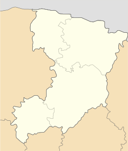
Kostopil urban hromada

Kostopil urban hromada
Костопільська міська громада
Kostopil urban hromada is located in Rivne Oblast
Kostopil urban hromada
Kostopil urban hromada is located in Ukraine
Kostopil urban hromada
Coordinates: 50°52′59″N 26°26′46″E / 50.88306°N 26.44611°E / 50.88306; 26.44611
Country Ukraine
Oblast (province) Rivne Oblast
Raion (district)Rivne Raion
Administrative centerKostopil
Area
 • Total
653.4 km2 (252.3 sq mi)
Elevation
182 m (597 ft)
Population
 (2022)
 • Total
44,042
 • Density67/km2 (170/sq mi)

Kostopil urban territorial hromada (Ukrainian: Костопільська міська територіальна громада, romanizedKostopilska miska terytorialna hromada) is a hromada located in the Rivne Oblast of western Ukraine. Its seat of government is the city of Kostopil. The hromada currently covers an area of 653.4 square kilometers, and has a total population of 44,042 (2022 est.)[1]

Climate

Kostopil urban hromada has a humid continental warm summer climate (Dfb). It sees the least rainfall in February, with an average precipitation of 42 mm; and the most in July, with 107 mm of average rainfall.

Climate data for Kostopil
Month Jan Feb Mar Apr May Jun Jul Aug Sep Oct Nov Dec Year
Mean daily maximum °C (°F) −1.2
(29.8)
0.4
(32.7)
6.1
(43.0)
13.9
(57.0)
19.4
(66.9)
22.5
(72.5)
24.4
(75.9)
23.8
(74.8)
18.5
(65.3)
12
(54)
6.1
(43.0)
1
(34)
12.2
(54.1)
Daily mean °C (°F) −3.3
(26.1)
−2.3
(27.9)
2.1
(35.8)
9.1
(48.4)
14.7
(58.5)
18.3
(64.9)
20.1
(68.2)
19.4
(66.9)
14.4
(57.9)
8.5
(47.3)
3.8
(38.8)
−0.9
(30.4)
8.7
(47.6)
Mean daily minimum °C (°F) −5.7
(21.7)
−5.2
(22.6)
−1.9
(28.6)
3.9
(39.0)
9.4
(48.9)
13.3
(55.9)
15.4
(59.7)
14.7
(58.5)
10.3
(50.5)
5.2
(41.4)
1.5
(34.7)
−3
(27)
4.8
(40.7)
Average rainfall mm (inches) 45
(1.8)
42
(1.7)
49
(1.9)
53
(2.1)
72
(2.8)
83
(3.3)
107
(4.2)
70
(2.8)
66
(2.6)
49
(1.9)
50
(2.0)
49
(1.9)
735
(29)
Source: Climate-Data.org[2]

Settlements

The hromada comprises one city, Kostopil, and the following 29 villages:[1]

  • Bryushkiv
  • Huta
  • Komarivka
  • Korchivia
  • Kosmachiv
  • Ledne
  • Maidan
  • Maly Mydsk
  • Maly Stydyn
  • Marianivka
  • Mokvynski Khutory
  • Oleksandrivka
  • Osova
  • Penkiv
  • Pidluzhne
  • Piskiv
  • Rokytne
  • Rudnia
  • Trostianets
  • Trubytsi
  • Velyka Liubasha
  • Velykyi Mydsk
  • Velykyi Stydyn
  • Volytsia
  • Yapolot
  • Yasnobir
  • Zbuzh
  • Zhalyn
  • Zolotolyn

History

Since 1939, this region had been a part of Kostopil Raion. On 12 June 2020, the government of Ukraine approved Decree No. 722-r, which reformed the administrative divisions of Rivne Oblast. Under this decree, Kostopil Raion was merged into Rivne Raion, and its territory was divided into two territorial hromadas: Holovyn and Kostopil.[3]

See also

References

  1. ^ a b Автор. "Децентралізація в Україні". decentralization.gov.ua (in Ukrainian). Retrieved 2023-03-20.
  2. ^ "Kostopil climate: Temperature Kostopil & Weather By Month - Climate-Data.org". en.climate-data.org. Retrieved 2023-03-20.
  3. ^ Kitsoft. "Кабінет Міністрів України - Про визначення адміністративних центрів та затвердження територій територіальних громад Рівненської області". www.kmu.gov.ua (in Ukrainian). Retrieved 2023-03-20.