|
Kitadaitō, Okinawa
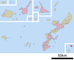
Kitadaitō (北大東村, Kitadaitō-son) is a village consisting of the islands of Kitadaitōjima and Okidaitōjima of Shimajiri District, Okinawa Prefecture, Japan. As of October 2016, the village has an estimated population of 615 and a density of 47 persons per km2. The total area is 13.10 km2. All of the inhabitants live on Kitadaitōjima. GeographyKitadaitō Island is located about 360 km east of Okinawa Island. It is the easternmost island in Okinawa Prefecture. The island shows characteristic landscape of a raised coral reef island, with a very flat area in its centre.[1] Okidaitō Island is entirely the private property of the Rasae Group, that used to exploit phosphate ore there. It was then rented by the U.S. Forces in Japan as a shooting range, that started to be used conjointly by the Japan Self Defence Forces in 2015. It is off limits to civilians and currently uninhabited.[2] Area
Administrative divisionsThe village includes four wards.[4]
Group of Water Collecting PondsKitadaitō Village does not present, as Minamidaitō Village, many natural bogs. There is, in the centre of the island, a large fresh water pond, the level of which changes with the tides due to the freshwater lens effect. This pond used to be a very valuable water resource before the desalination process enabled the creation of a tap water network in the village. It is currently only used for agricultural purposes. There are also many artificial water ponds, such as the "East Water Tank" that is the easternmost water tank of Okinawa Prefecture, the "Red Pond" located in front of the sugar factory or the many smaller agricultural ponds. This water is an important resource for the irrigation of the 274 ha (50% of the island area) of sugar cane fields. The sixteen water ponds of Kitadaitō have been registered on the "One Hundred Noticeable Water Pond List" of the Ministry of Agriculture and Forestry on March the 25th 2010.[5] Those ponds are important resting places for migrating birds such as ospreys, black kites, grey-faced buzzards or herons and a famous birdwatching spot. Every year on the Sugar Cane Day (4th Sunday of April), the residents and the Children Association clean around the ponds.[6] ClimateKitadaitō has a tropical rainforest climate (Köppen climate classification Af) with very warm summers and mild winters. Precipitation is significant throughout the year; the wettest month is June and the driest month is February. The island is subject to frequent typhoons.
HistoryKitadaitōjima remained uninhabited until formally claimed by the Empire of Japan in 1885. In 1900, a team of pioneers from Hachijōjima became the first human inhabitants of the island, and started the cultivation of sugar cane from 1903. Until World War II, Kitadaitōjima was owned in its entirety by Dai Nippon Sugar (now Dai Nippon Meiji Sugar), which also operated mines for the extraction of guano for use in fertilizer. After World War II, the island was occupied by the United States. The village of Kitadaitō was established in 1946. The island was returned to Japan in 1972. Economy Formerly heavily dependent on phosphate mining, the village economy is now based on cultivation of sugar cane, commercial fishing, and seasonal tourism. There is no port on the island and ships must be loaded/offloaded by crane. TransportThe island has an airport, Kitadaito Airport, with one flight a day to Minami-Daito Airport Education There is the Kitadaito Village Kitadaito Elementary-Junior High School (北大東村立北大東小中学校 Kitadaitō Sonritsu Kitadaitō Shōchūgakkō) and the Kitadaito Village Kitadaito Kindergarten (北大東村立北大東幼稚園 Kitadaitō Sonritsu Kitadaitō Yōchien).[9] Cultural Properties
References
External links
|
||||||||||||||||||||||||||||||||||||||||||||||||||||||||||||||||||||||||||||||||||||||||||||||||||||||||||||||||||||||||||||||||||||||||||||||||||||||||||||||||||||||||||||||||||||||||||||||||||


