|
Keroun, Kanepokhari
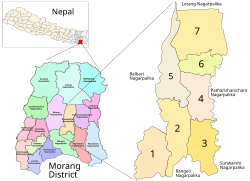
Keroun Bazar is a village in Ward 2 of the Kanepokhari Rural Municipality of the Morang District in Province No. 1 of south-eastern Nepal. Keroun was formerly a Village development committee (VDC), but was incorporated into Kanepokhari when that rural municipality was created in 2017. LocationThe Keroun VDC was in Nepal, Eastern Region, Kosī Zone, Morang. It is at an elevation of about 105 metres (344 ft).[1] Google Maps shows Keroun Bazar on the Kanepokhari-Rangeli road to the north of Daleli and the south of Ramailo.[2] References
|
||||||||||||||||||||||

