Hurricane Celia was the costliest tropical cyclone in Texas history until Hurricane Alicia in 1983. The third named storm, second hurricane, and first major hurricane of the 1970 Atlantic hurricane season, Celia developed from a tropical wave in the western Caribbean Sea on July 31. Initially, the depression tracked north-northwestward without significantly strengthening, and crossed over western Cuba on August 1. Heavy rains on the island caused severe flooding, leading to five fatalities. The depression entered the Gulf of Mexico and was upgraded to Tropical Storm Celia later on August 1. Due to warm sea surface temperatures, Celia rapidly intensified into a major hurricane on August 1 and after the creation of the Saffir–Simpson hurricane wind scale in 1971 it was estimated to have been a Category 3 storm. Storm surge and swells lashed the west coast of Florida, especially the Panhandle, causing eight people to drown. Early on August 2, Celia began to weaken. However, the storm underwent rapid deepening again and peaked as a Category 4 hurricane with winds of 140 mph (220 km/h) on August 3.
In Louisiana, tides caused minor coastal flooding. Minor erosion damage was reported along Highway 82 in Cameron Parish. Late afternoon on August 3, Celia made landfall near Corpus Christi, Texas. Throughout the state, 8,950 homes were destroyed and damaged about 55,650 others. About 252 small businesses, 331 boats, and 310 farm buildings were either damaged or destroyed. Impact was the worst in Nueces County, which observed gusts as high as 180 mph (290 km/h). In Corpus Christi, about one-third of houses suffered severe damage or were destroyed. Additionally, about 90% of the buildings in downtown were damaged to some degree. Celia weakened as it continued further inland and dissipated over New Mexico on August 6. The remnants of Celia brought up to 2 inches (51 mm) of rainfall to the state. Overall, this storm caused 28 deaths and $930 million (1970 USD) in damage.
Meteorological history
Map plotting the storm's track and intensity, according to the Saffir–Simpson scale[nb 1]
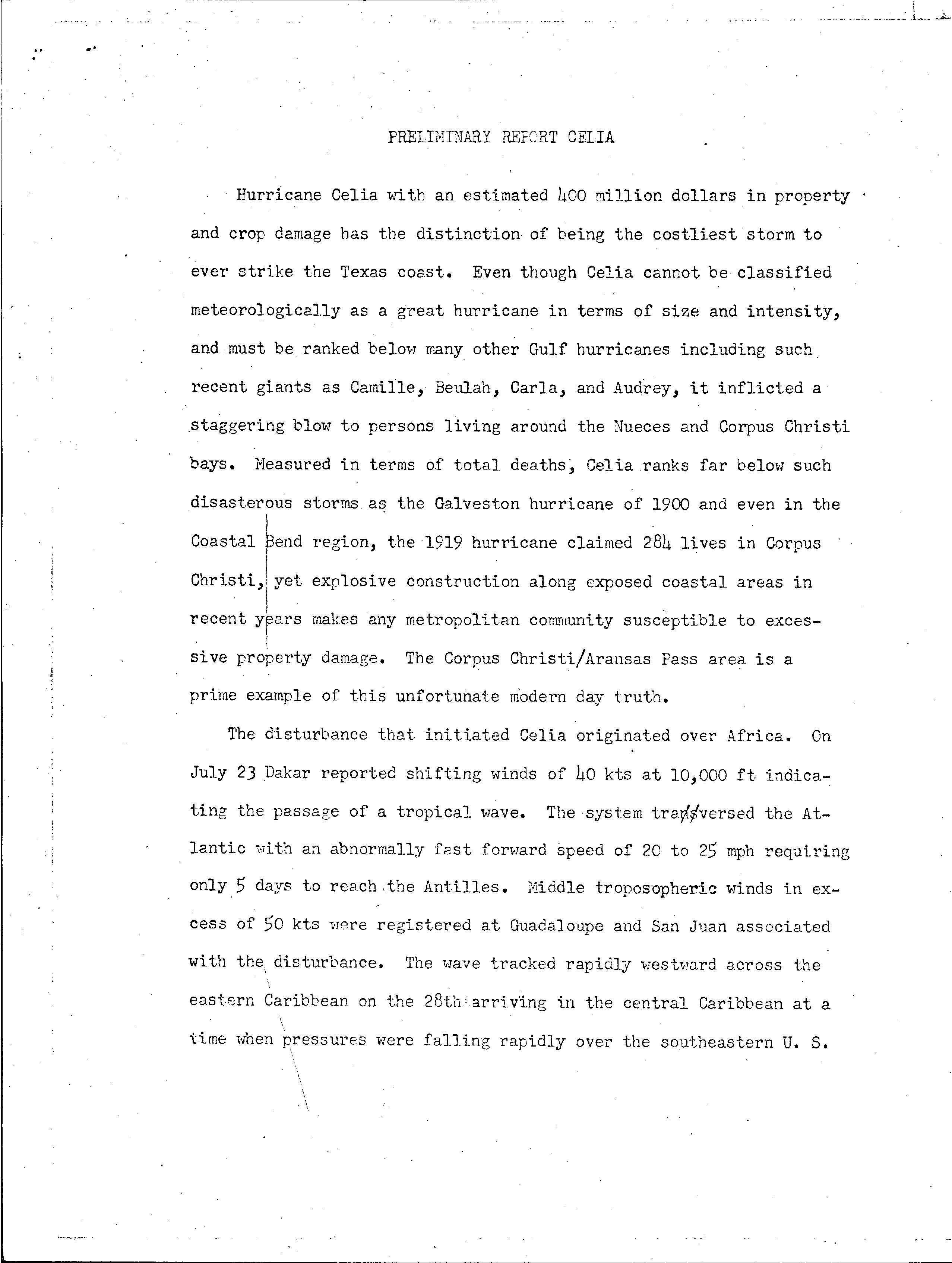
A tropical wave emerged into the Atlantic Ocean from the west coast of Africa in late July; a weather station in Dakar, Senegal observed a wind shift on July 23. The system moved quickly across the Atlantic at 20 and 25 mph (32 and 40 km/h) and reached the Lesser Antilles by July 28.[1] The wave then continued moving rapidly westward across the Caribbean Sea. However, falling atmospheric pressures over the Southern United States eroded a subtropical ridge, causing the system to decelerate by July 30. Around that time, a closed circulation began to organize in the northwestern Caribbean between the Cayman Islands and Swan Island.[2] At 0000 UTC on July 31, a tropical depression developed about 90 mi (145 km) west-southwest of Grand Cayman.[3] The depression strengthened while heading north-northwestward, though a reconnaissance aircraft could not complete its mission on July 31 due to the depression's proximity to Cuba.[2]
Early on August 1, the depression made landfall in western Pinar del Río Province, Cuba.[3] A weather station in Cape San Antonio recorded a minimum barometric pressure of 1,007 mbar (29.7 inHg). After reaching the southeastern Gulf of Mexico on August 1, warm sea surface temperatures caused the depression to undergo rapid deepening. Later that day, the depression reached tropical storm intensity and was named "Celia", based on a reconnaissance flight observing tropical storm force winds.[2] Satellite imagery indicated that Celia was becoming significantly more organized.[4] At 0000 UTC on August 2, reconnaissance aircraft data indicated that Celia suddenly strengthened into a Category 3 hurricane with sustained winds of 115 mph (185 km/h).[3][4] However, the storm weakened to a Category 2 hurricane about six hours later.[3] Due to Celia's steady west-northwestward motion across the Gulf of Mexico, the National Hurricane Center marked that the storm "aimed at the Corpus Christi area like a wild beast stalking its prey."[4] Early on August 3, it weakened further to a Category 1 hurricane.[3]
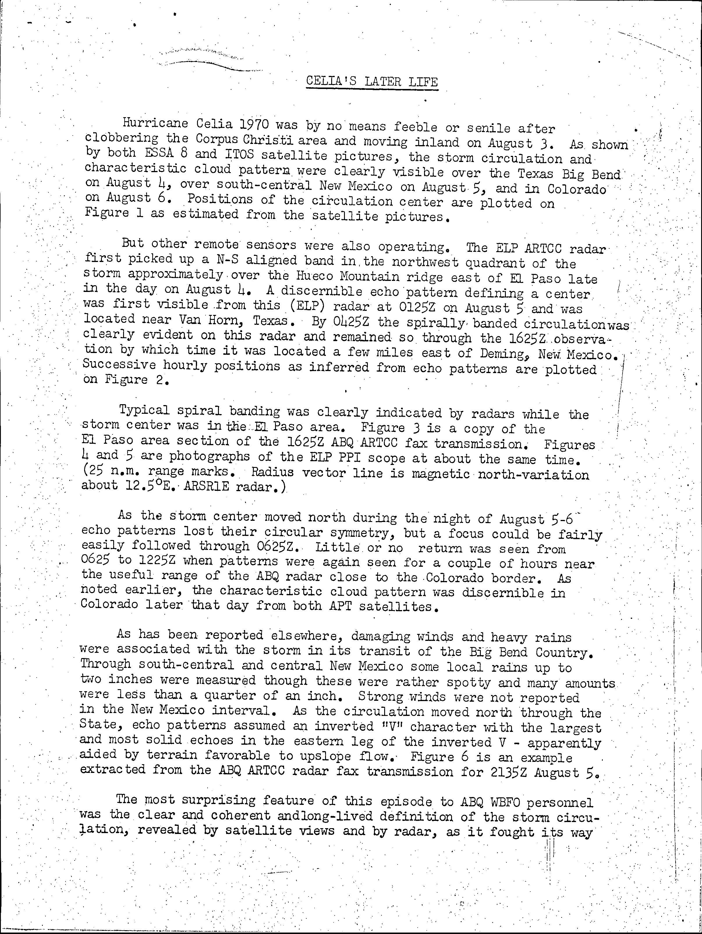
As it turned towards the coast, Celia once again intensified very rapidly on August 3, including a 39 mbar (1.2 inHg) decrease in pressure in only 15 hours, and strengthened quickly right up to landfall along the Texas coast.[4] At the time of landfall, which took place at 2100 UTC on August 3, Celia attained its peak intensity with maximum sustained winds of 140 mph (220 km/h) and a minimum barometric pressure of 944 mbar (27.9 inHg).[3] Celia "maintained strength for an unusually long time" after moving inland,[4] weakening to a tropical storm at 1200 UTC on August 4. Early on the following day, the storm further weakened to a tropical depression. Celia dissipated over western Texas at 1800 UTC on August 5,[3] though the remnants persisted until reaching New Mexico.[5]
Preparations
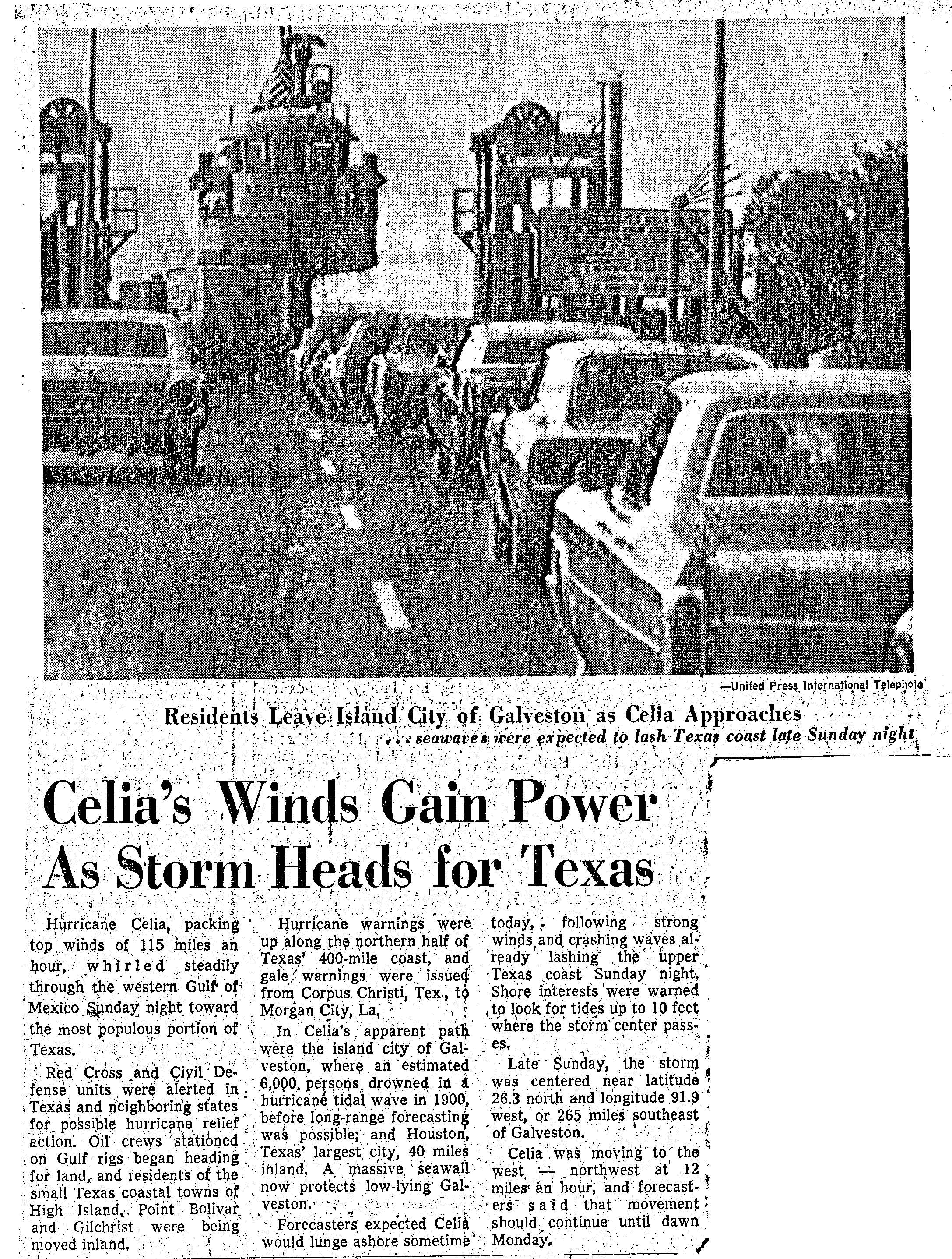
In the Gulf of Mexico, oil rig crew workers began leaving and headed for land. Residents of Texas coastal towns of High Island, Port Bolivar, and Gilchrist were evacuated further inland.[6] The National Hurricane Center also issued tropical cyclone warnings and watches along the coast of Texas in anticipation of the storm. At 1600 UTC on August 2, a hurricane warning was posted from Palacios to Port Arthur. About six hours later, the warning was extended southward to Rockport. The hurricane warning was expanded further southward to Corpus Christi at 1000 UTC on August 3.[7]
Celia was initially forecast to stay well north of Corpus Christi. However, on August 3, the forecast depicted a direct hit on the city. With little warning, many residents did not have enough time to make correct preparations.[8]
Impact
Celia caused 27 fatalities, four in Cuba, eight in Florida and 15 in Texas and left $930 million in damages.[9]Corpus Christi, Texas suffered the worst impact, with at least 85% of all the structures in the city damaged, with 90% of downtown buildings were damaged or destroyed. Additionally, about one-third of houses were severely damaged or flattened.[10]
Cuba and Florida
As a tropical depression, Celia dropped heavy rains over western Cuba, resulting in major flooding. Four people drowned and another man was electrocuted in the water when he tried to retrieve a downed power line.[2] While over the central Gulf of Mexico, strong rip currents and large swells affected Florida, measuring up to 10 feet (3.0 m) in the Panhandle. In Escambia County alone, at least 12 lifeguard rescues occurred. Pensacola Beach was closed to the public on September 3, after several rescues on the previous day. Eight people drowned due to adverse water conditions in the Florida Panhandle.[10]
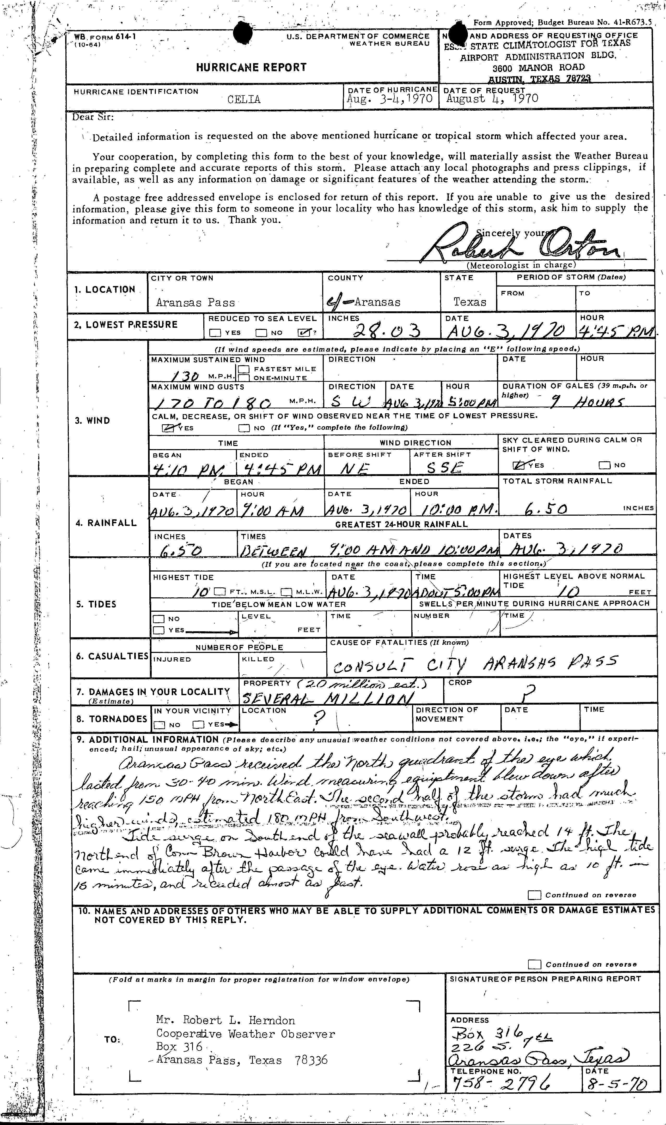
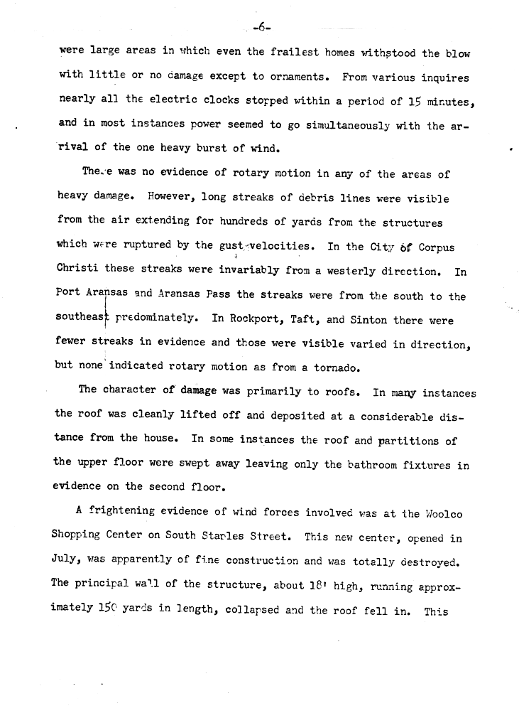
The most severe damage was in Corpus Christi[11] and Aransas Pass. Throughout the state, 8,950 homes were destroyed and it damaged about 55,650 others. About 252 small businesses, 331 boats, and 310 farm buildings were either damaged or destroyed. Initially, losses were estimated to have reached $434 million. However, due to lower insurance rate of coverage, the original insured losses, $310 million, were tripled, rather than doubled. Thus, the damage toll was revised upward to $930 million in 2011. Damage to crops was slightly more than $8.8 million. In addition, Celia caused 15 fatalities and injured 466 others. The most severe damage occurred in the streaks of damage, not by tornadoes, but a series microbursts and downbursts, most of which occurred in a 15-minute span. Survivors of the storm described the downbursts as "rocket shells" exploding.[12] However, areas between the streaks suffered surprisingly little damage, mainly ornamental due to debris from the homes nearby.[13] Celia dropped heavy rains as it made landfall. However, due to the small size and fast movement of the storm, precipitation was not widespread. At the time of landfall, much of Texas was suffering from a drought. Most areas received 3 to 4 in (76 to 102 mm).[14]
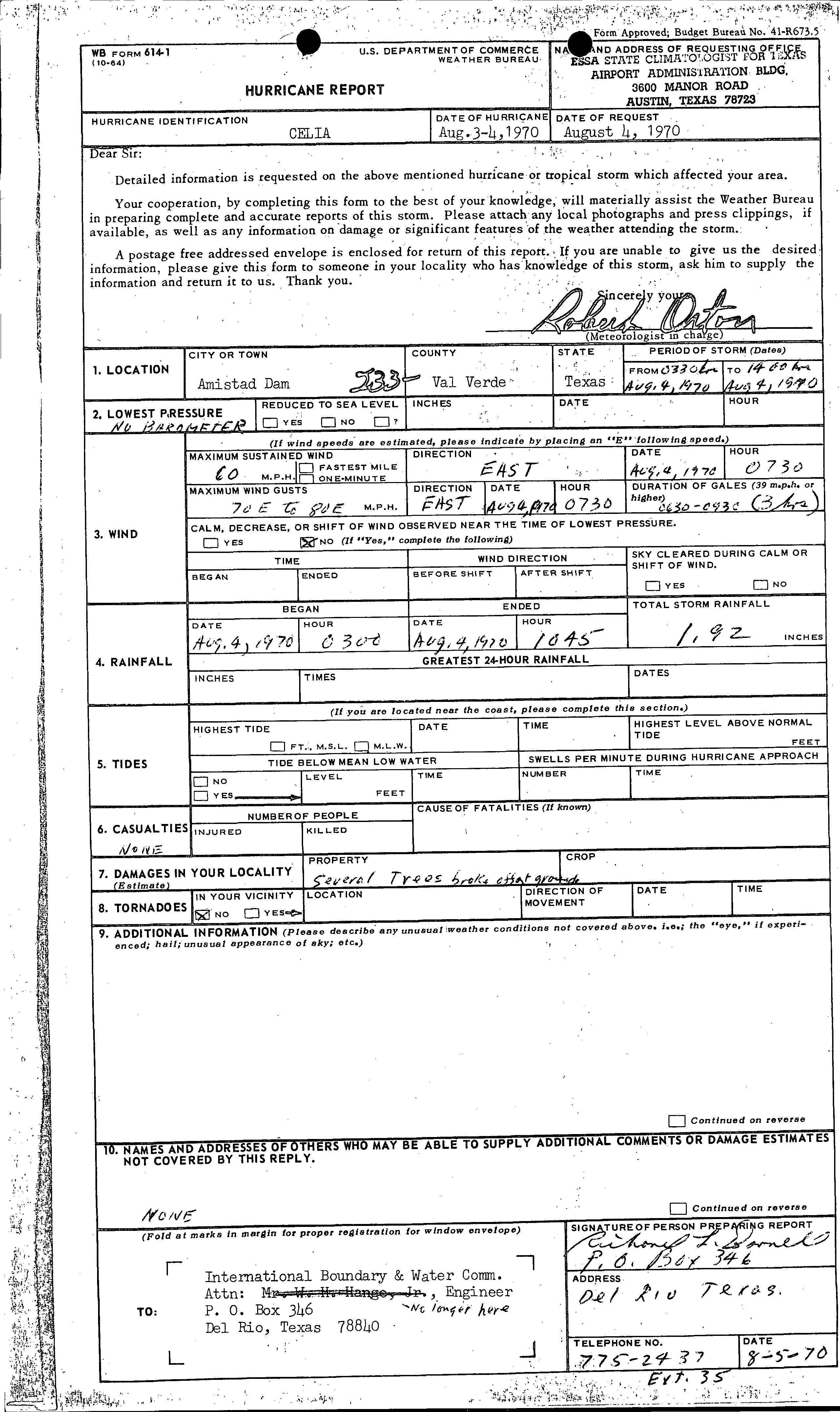
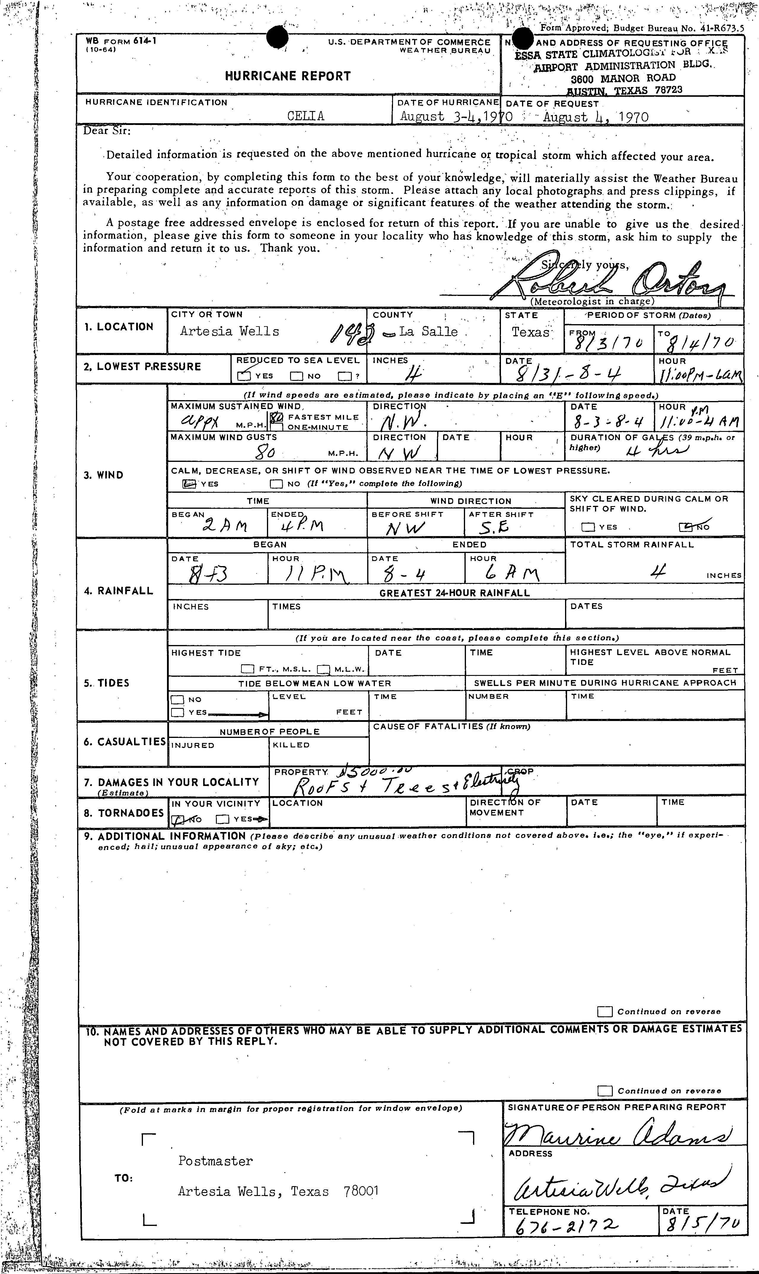
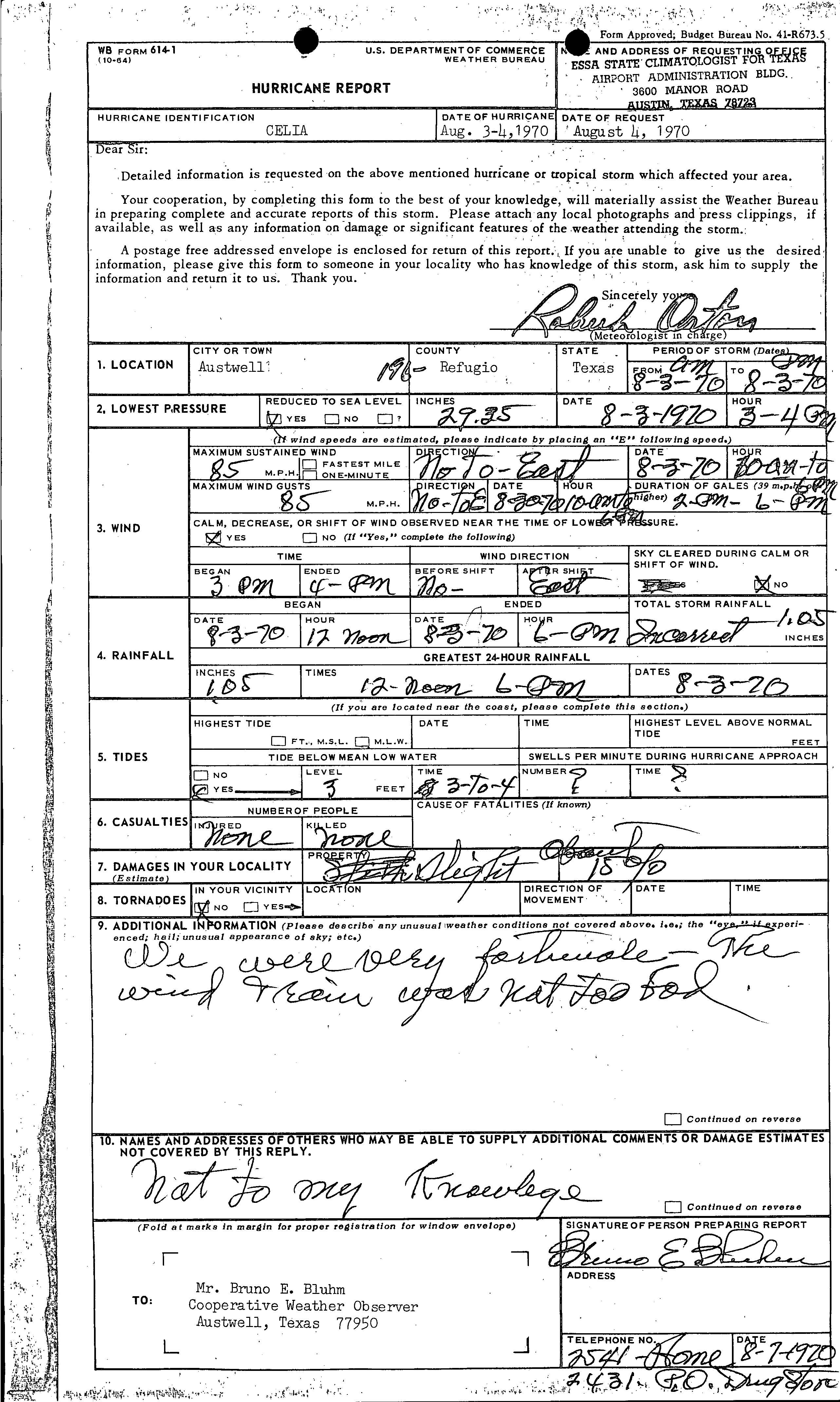
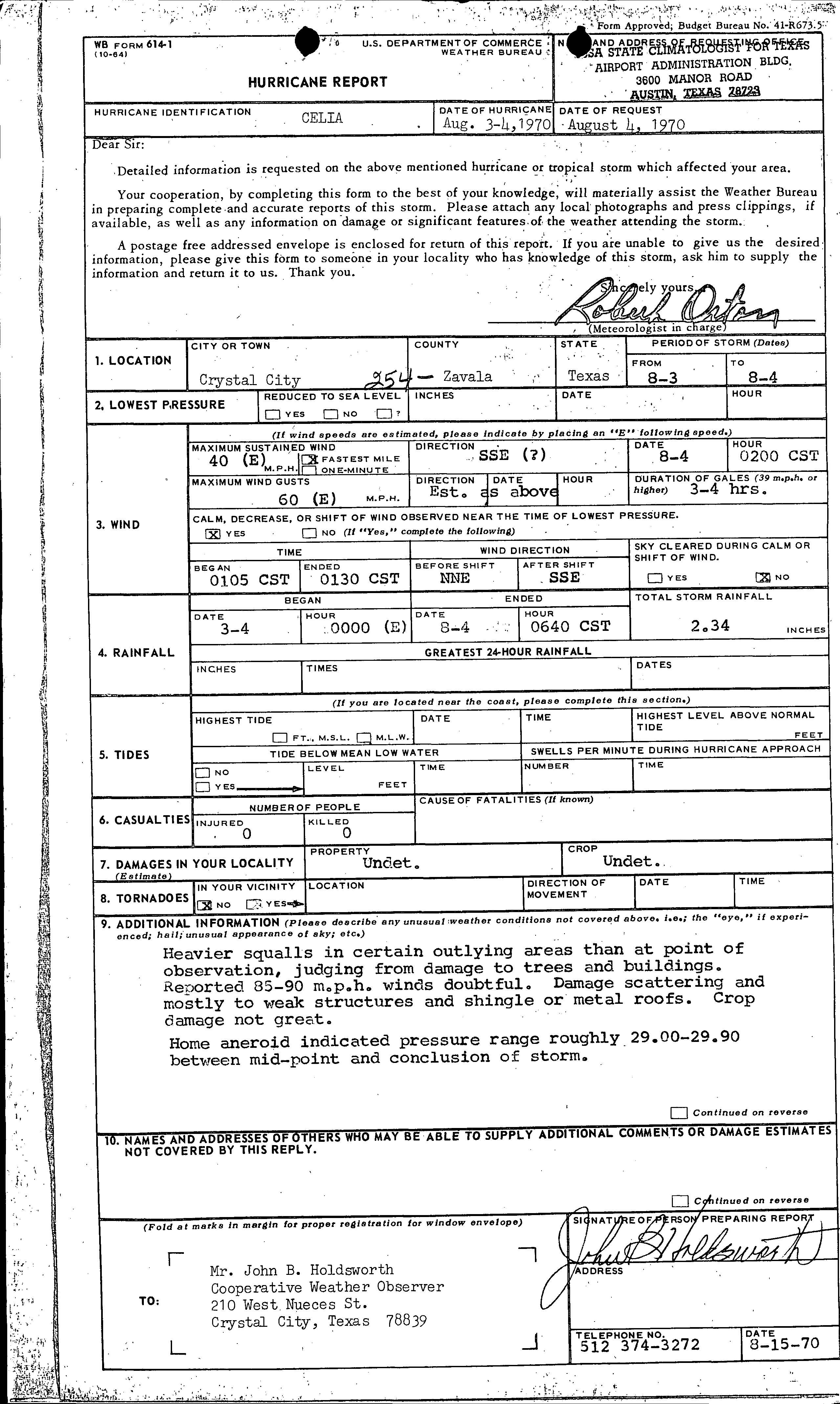
In Alvin, a small tornado caused the destruction of a few fences and moved a pickup truck.[10] Downed trees caused slight property damage in Amistad Dam, a municipality in Val Verde County.[15] Gusts between 170 and 180 mph (270 and 290 km/h) were reported within the Aransas County portion of Aransas Pass.[16] In Artesia Wells, minimal damage occurred to property, reaching only $5,000.[17] The storm damage some homes and 15% of crops in Austwell.[18] Losses in that section of the city reached an estimated $20 million. Minor damage was inflicted on weak structures and shingle or metal roofs in Crystal City. Impact on trees and crops were minimal. Thus, the reported wind speeds of 85–90 mph (137–145 km/h) were considered "doubtful".[19]
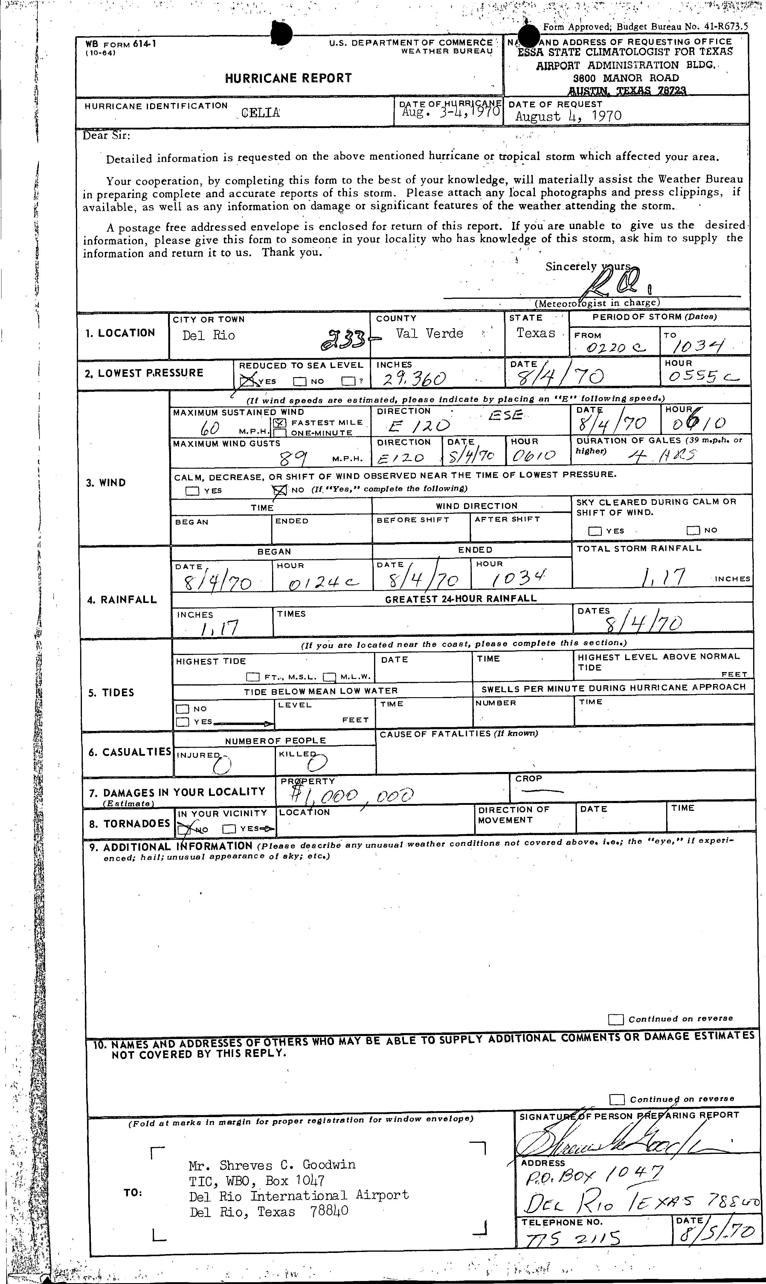
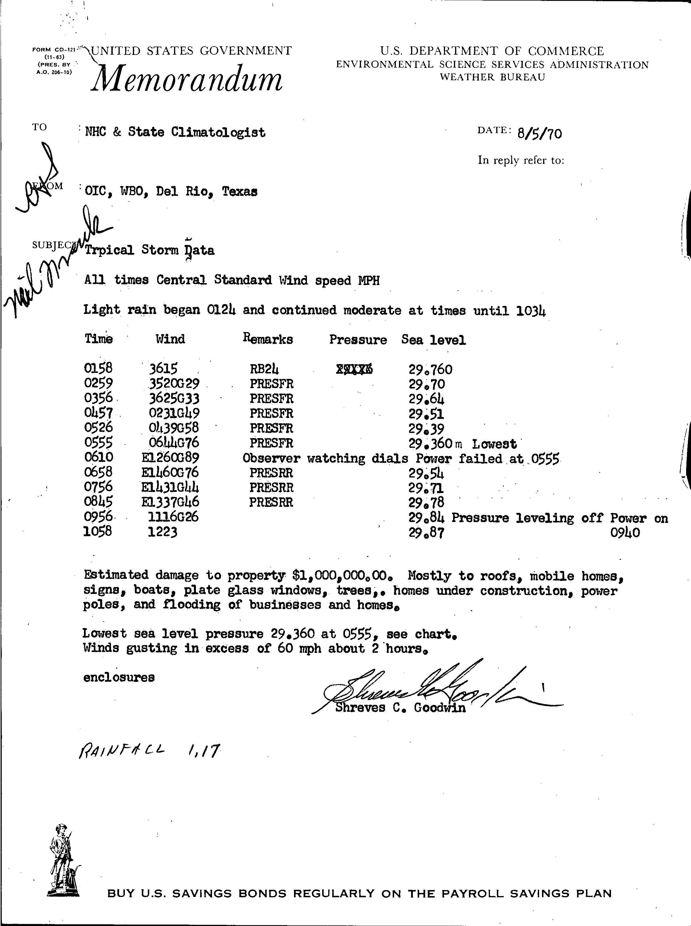
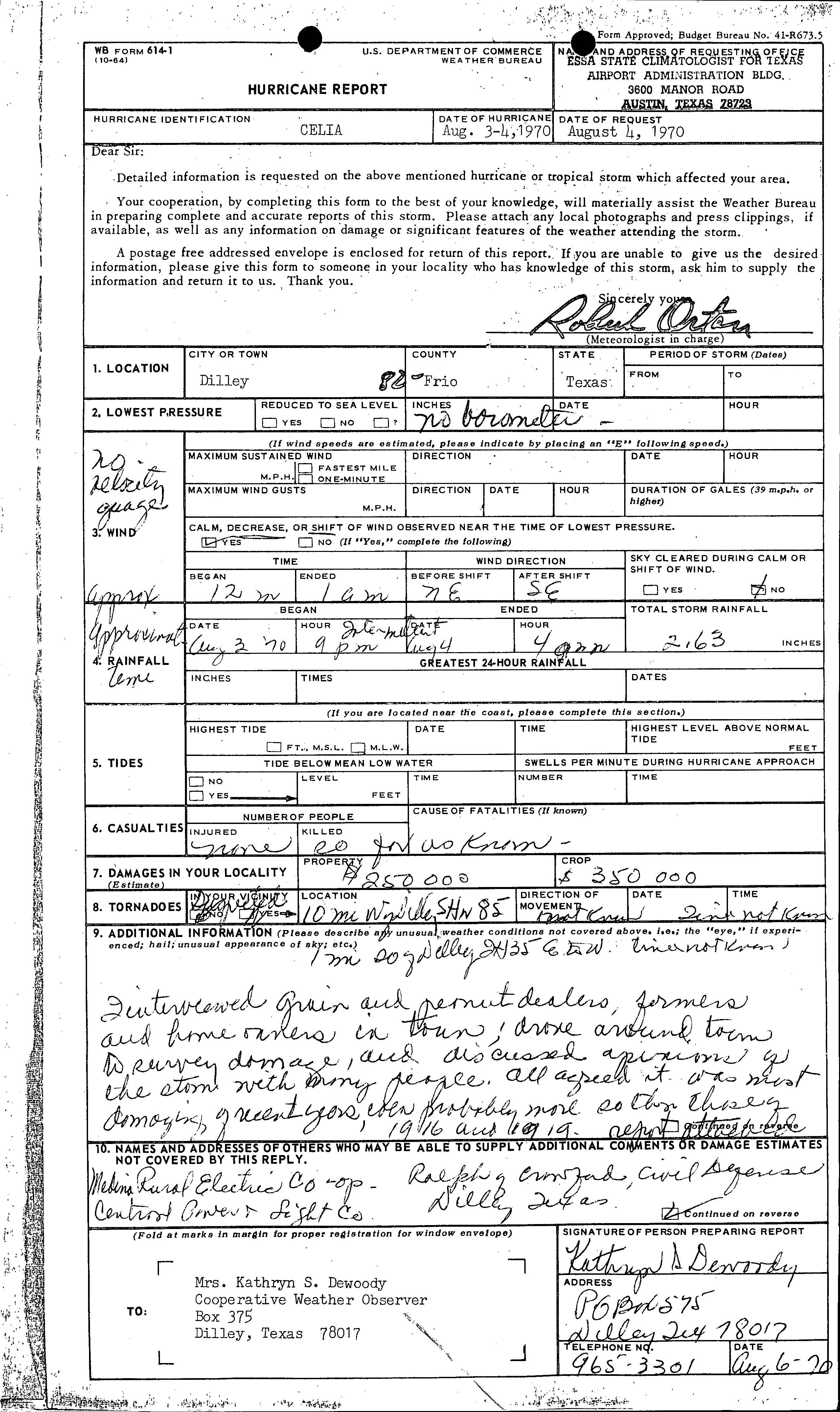
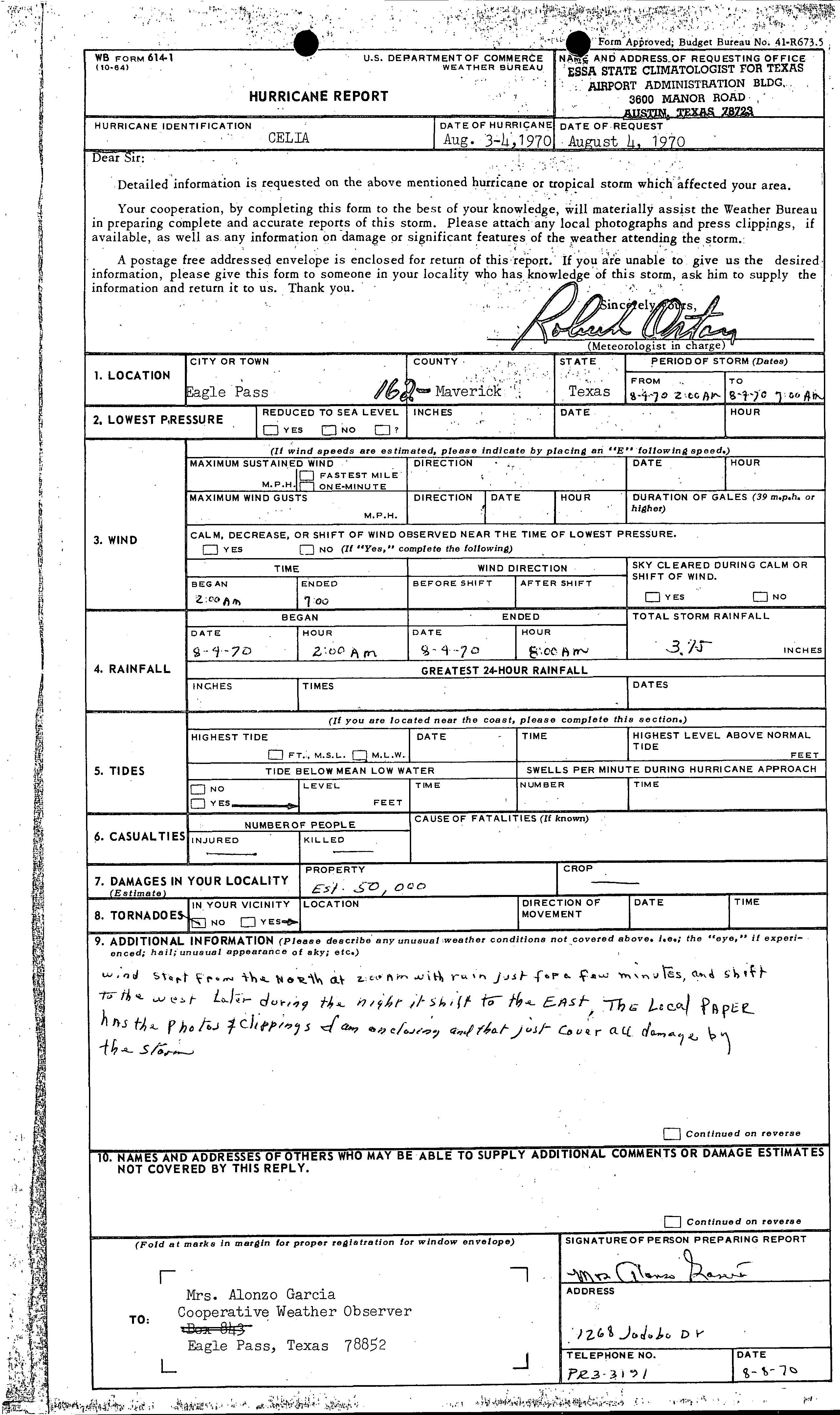
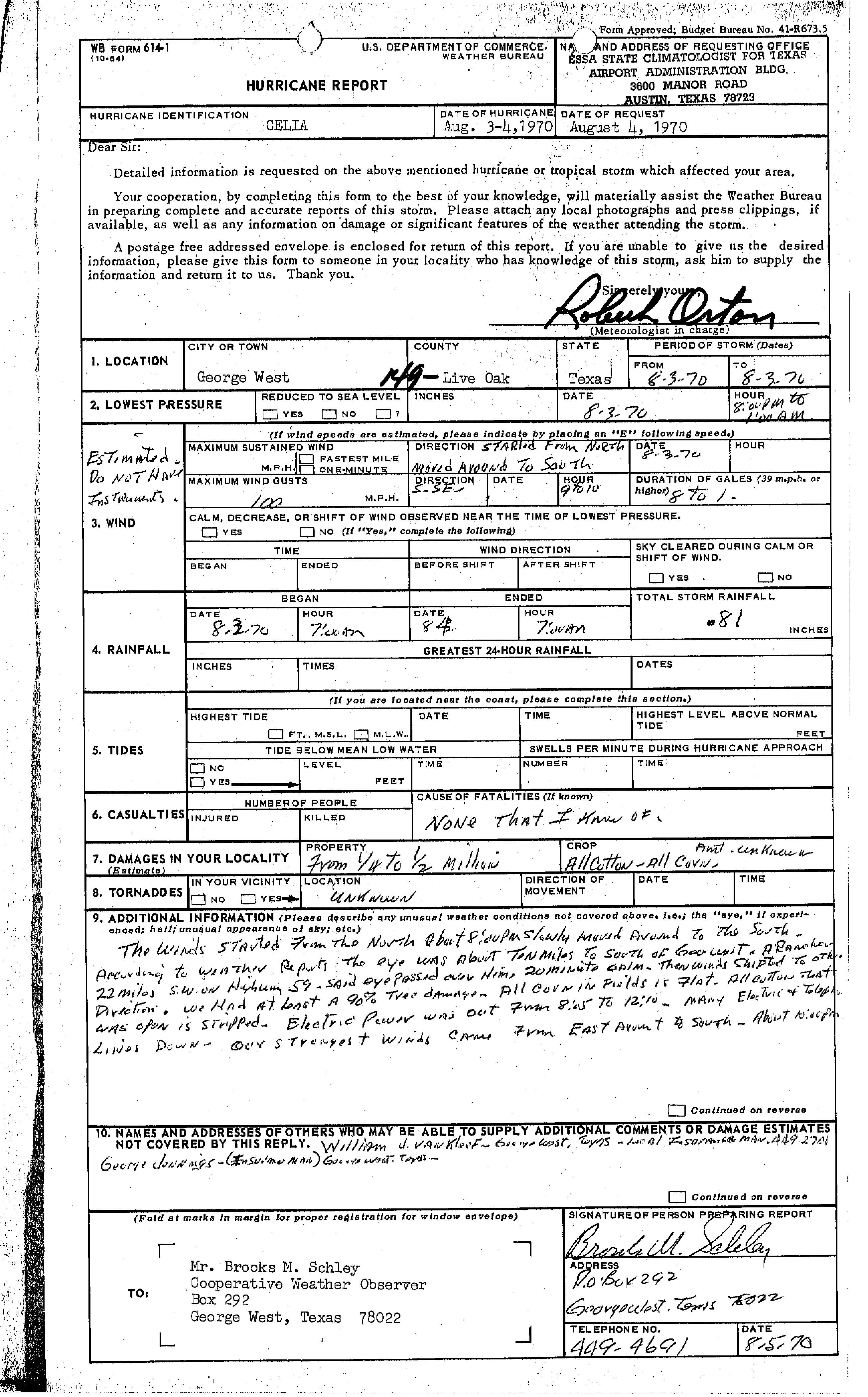
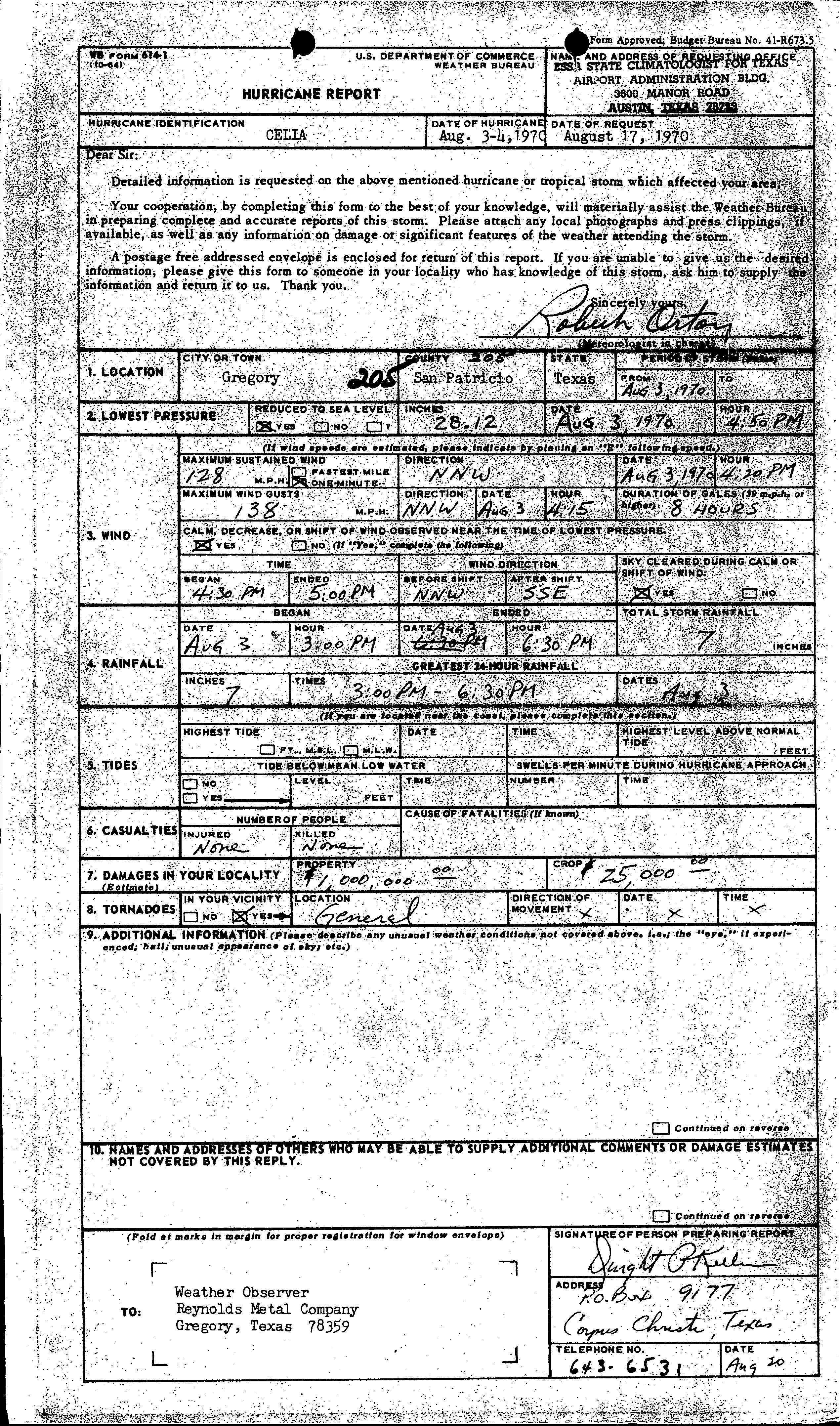
Property damage in Del Rio was about $1 million,[20] with wind impacts mostly to roofs, mobile homes, signs, boats, windows, trees, and homes under construction, while some businesses and homes were flooded.[21] In Frio County, a tornado spawned in the Dilley area toppled utility poles, destroyed several chicken houses, and blew the roof of a house 600 to 900 feet (180 to 270 m) away. In addition, two farm houses were deroofed and several outhouses were damaged. Another tornado spawned nearby caused "considerable" damage to the Dilley Civic Center, destroyed machine sheds, unroofed outbuildings, and felled many electrical poles.[10] Throughout Dilley, there was $250,000 in property damage and $350,000 in crop losses.[22] An estimated $50,000 was inflected to property in Eagle Pass.[23] Strong winds in George West caused damage to 90% of trees, some houses, and cotton crops. Damage estimates in the city range from $250,000–$500,000.[24] In Gregory, property losses was about $1 million, while there was about $25,000 in damage to crops.[25] Near Lake Corpus Christi, a man died after he was struck by debris from his house, which was hit by a tornado. Two other people were injured by that tornado and several homes were destroyed. The storm spawned at least 2 other tornadoes, those neither caused any known damage.[10]
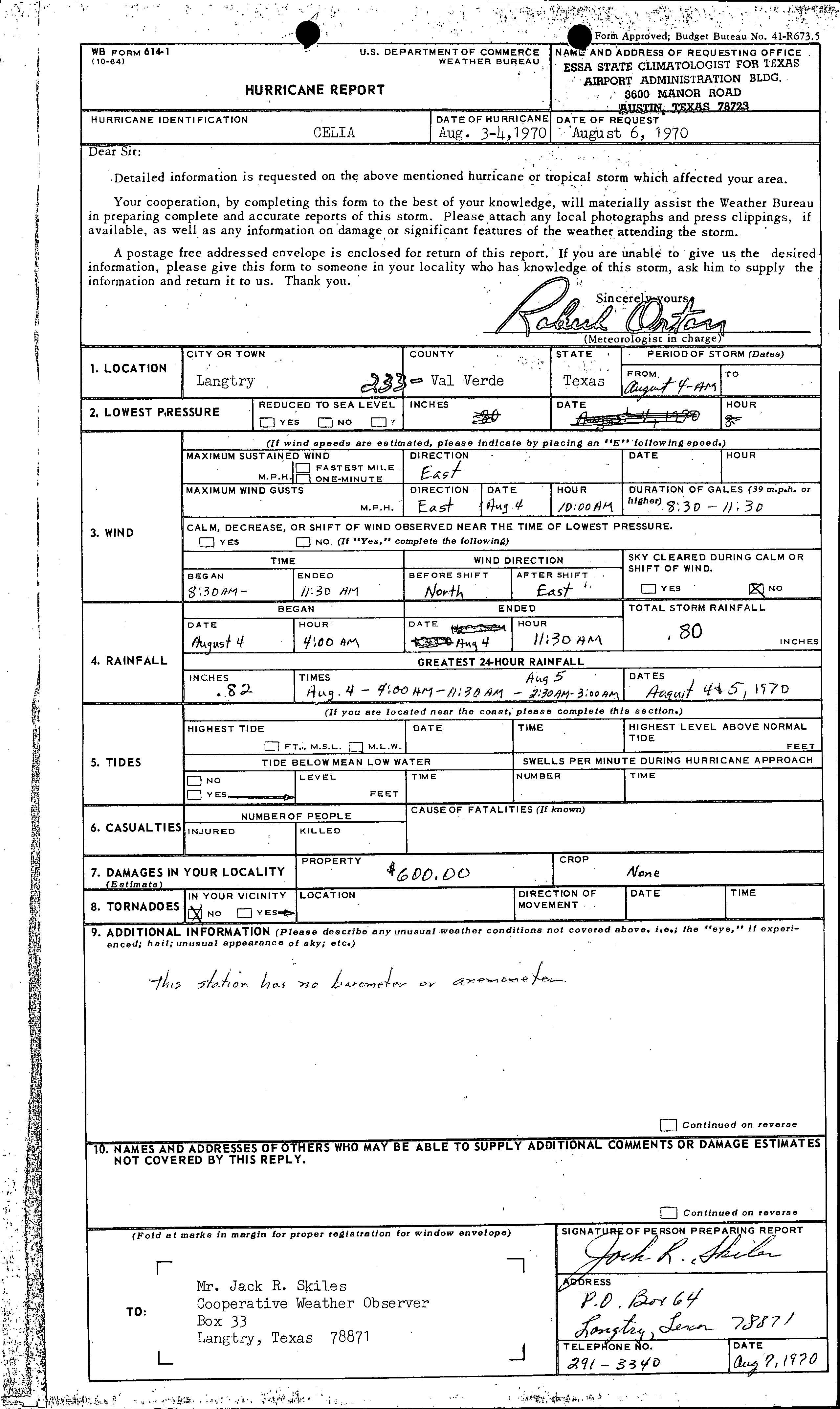
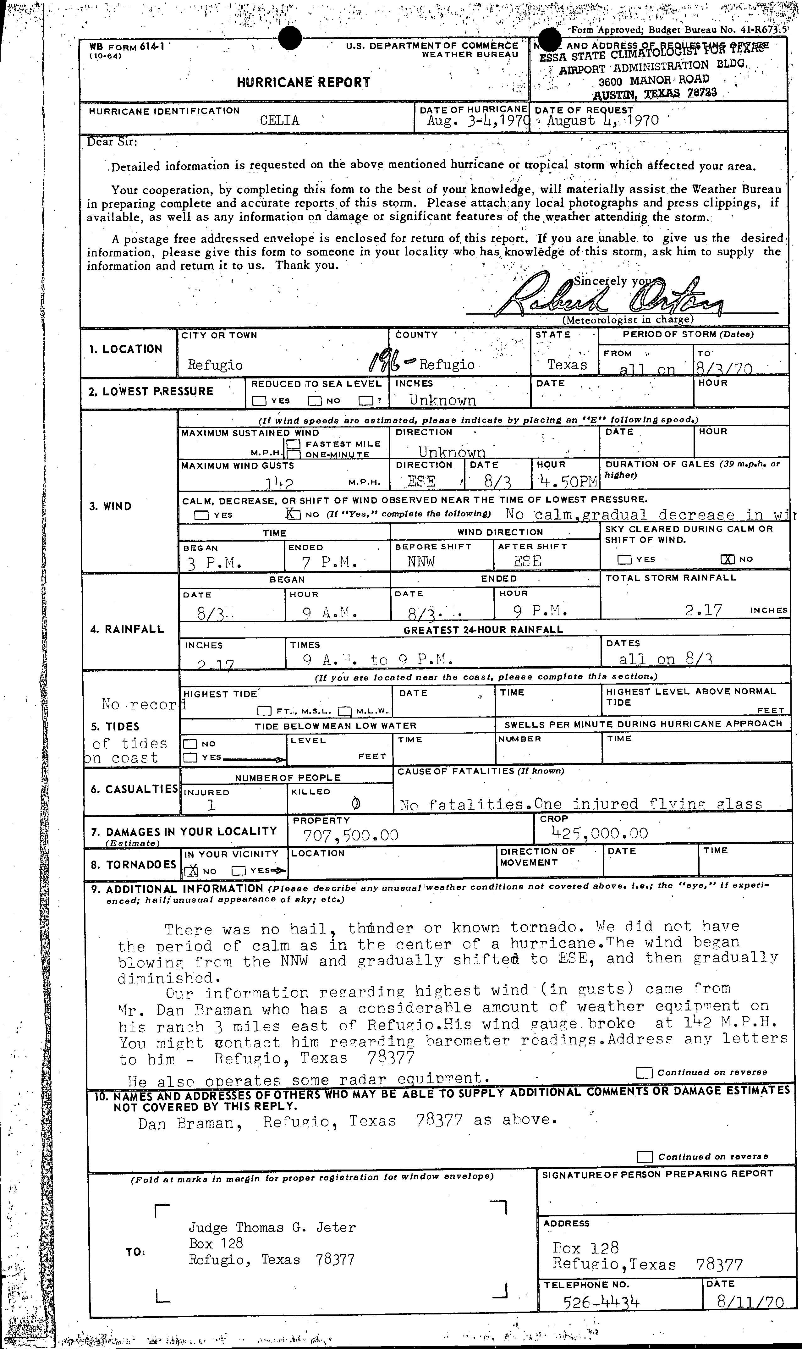
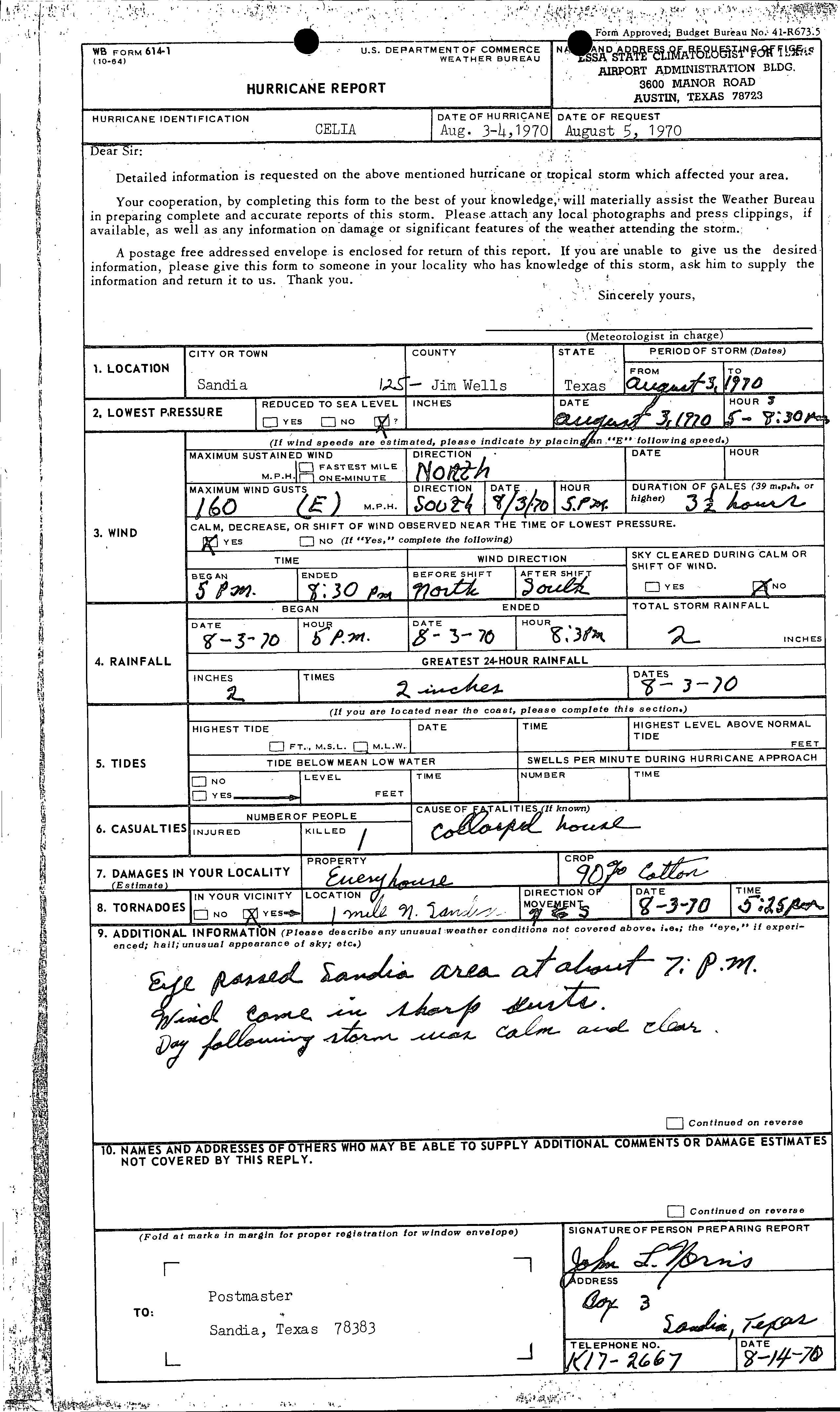
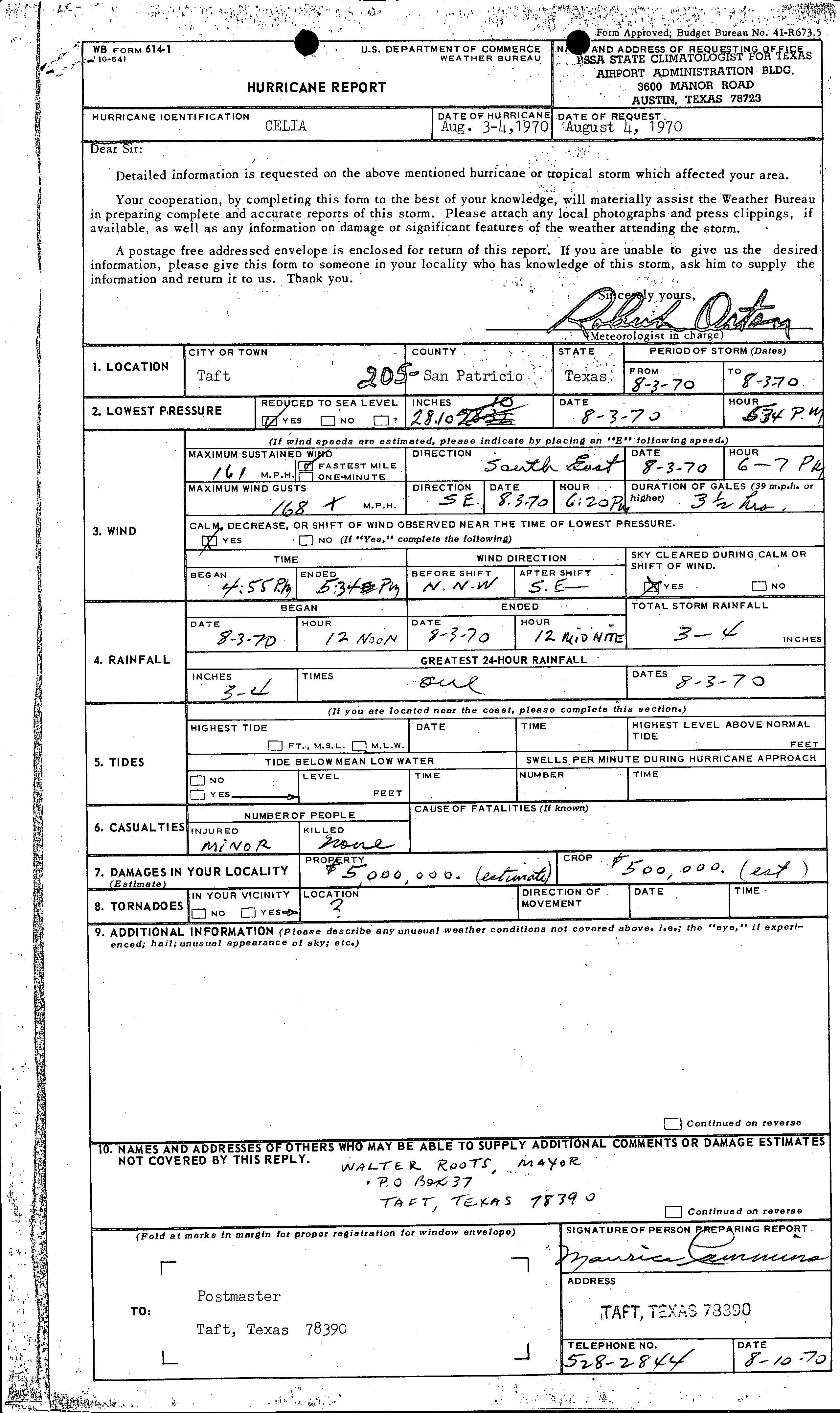
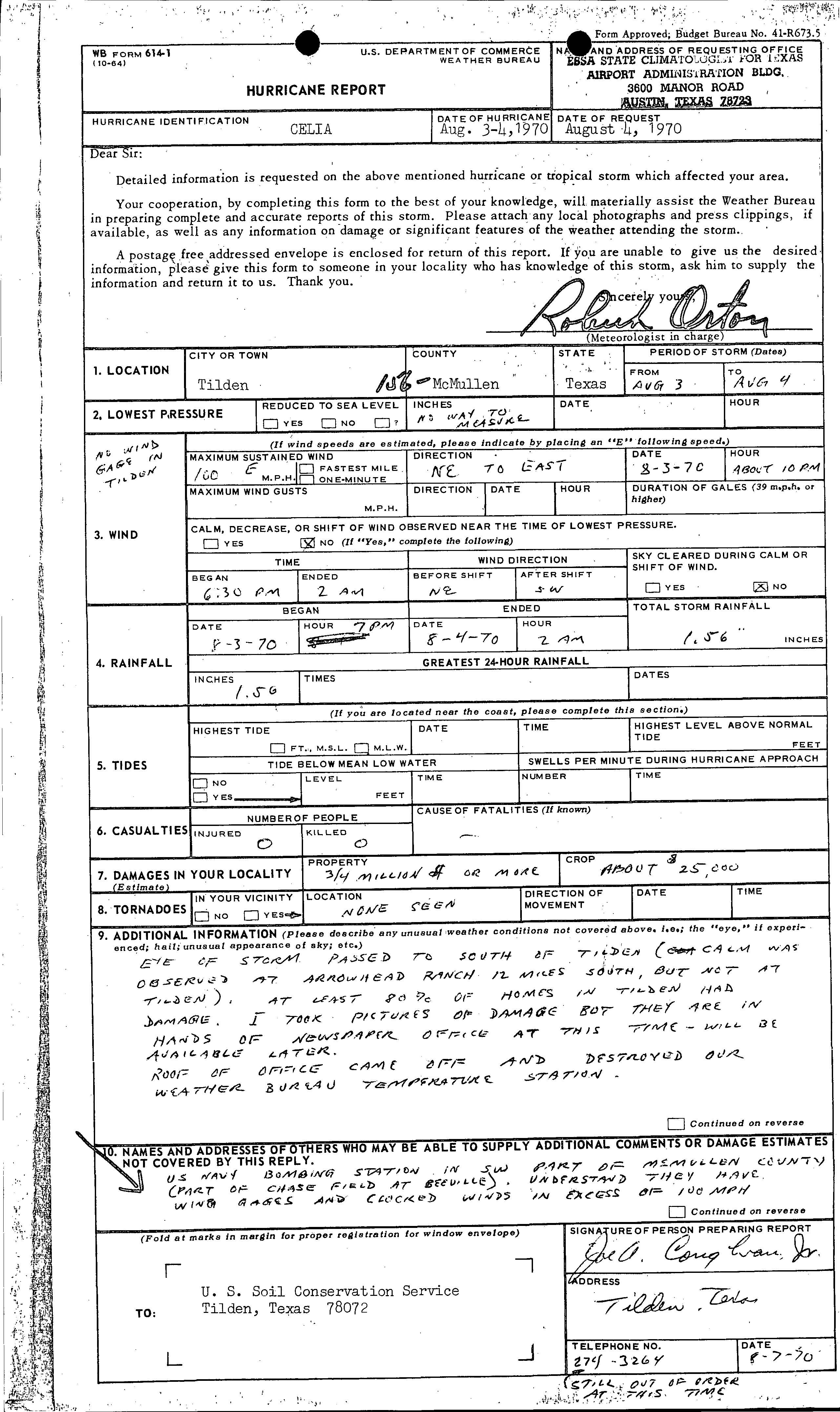
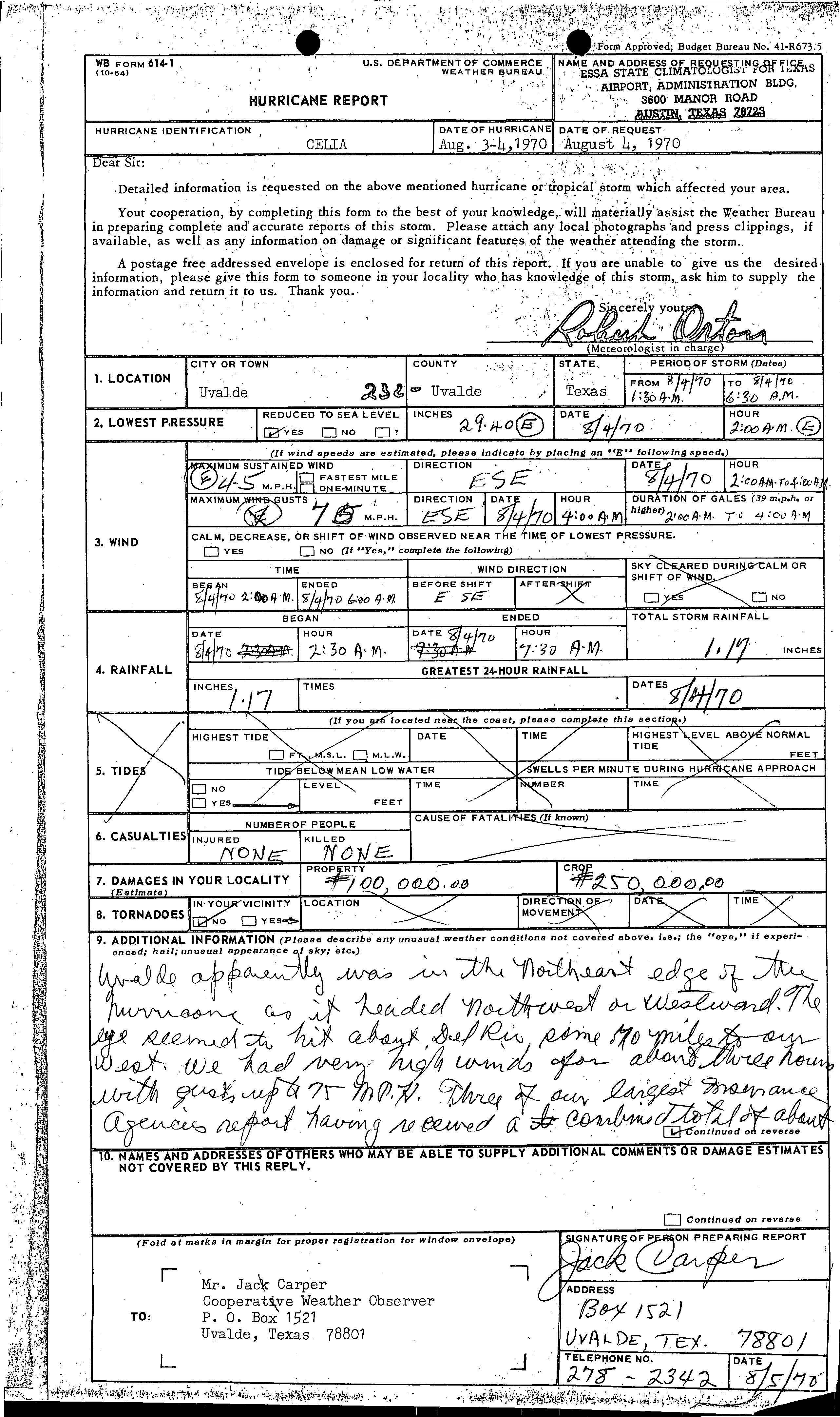
Damage in Langtry was very minor, reaching only $600.[26] A tornado in Port O'Connor, destroyed a 30 by 230 feet (9.1 by 70.1 m) boat storage shed, which was owned by Cooperative Weather Observed Bill H. Young.[10] In Refugio, a rancher observed wind gusts up to 142 mph (229 km/h). About $707,500 in damage occurred to property, while crop losses reached $425,000. One injury was reported after a person was struck by flying glass.[27] Wind gusts up to 160 mph (260 km/h) in Sandia damaged every house, 90% of cotton crops, and caused 1 fatality.[28] Although wind gusts of 168 mph (270 km/h) were observed in Taft, only $5 million in property and $500,000 in crop damages were reported.[29] In Tilden, the storm brought maximum sustained winds up to 100 mph (160 km/h). As a result, the entire city lost telephone and electrical services and there was "lots of damage" to trees, 80% of houses, and roofs. Property damage reached about $3.4 million, while there was also $25,000 in crop losses.[30] Property losses in Uvalde reached $100,000, while damage to crops was estimated at $250,000.[31] Additionally, a tornado was spawned in Yoakum, though it apparently caused negligible impact.[32]
Nueces County
Damaged building in Corpus Christi
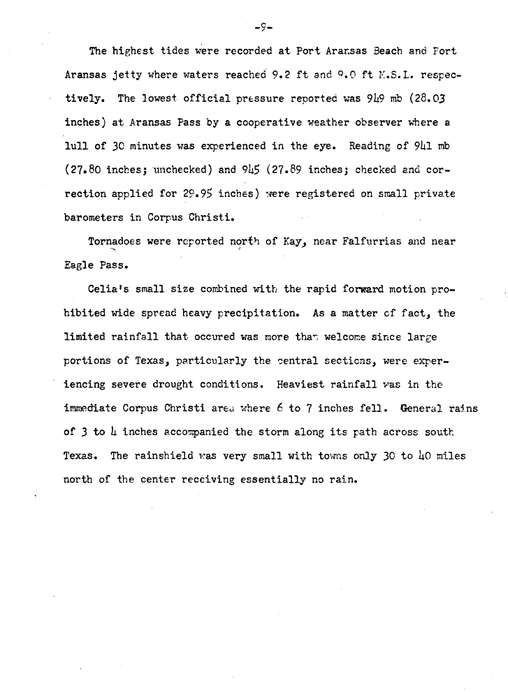
The highest tides produced by the storm lashed Nueces County. Tides were 9.2 feet (2.8 m) and 9 feet (2.7 m) mean sea level at Port Aransas Beach and the Port Aransas Jetty, respectively. The heaviest rainfall totals observed from the storm also fell in Nueces County, with 7.26 inches (184 mm) of precipitation reported in Robstown. Because rainfall was relatively light, minor, if any flood damage occurred. Strong winds were reported, with winds gusts measuring as high as 161 mph (259 km/h) and 180 mph (290 km/h) at the Corpus Christi Weather Bureau Office and Aransas Pass, respectively. Further inland, wind gusts were estimated to have reached 180 mph (290 km/h) at Robstown High School, as the oil derricks on the property, built to withstand winds of 175 mph (282 km/h), were knocked down.[10]
Due to high winds, 85% of the total property damage caused by the storm occurred in Corpus Christi, with 90% of the buildings in downtown either damaged or destroyed. About a third of the houses in the city had serious damage or were destroyed.[10] The University of Corpus Christi, a private institution located on Ward Island, suffered so much damage that it could not afford to rebuild, and it was sold to the State in 1973. Just northeast of the Corpus Christi International Airport, several hundred mobile homes were ripped into small fragments, and the remains were scattered for hundreds of yards. Facilities owned by the Southwestern Bell Corporation (which later became AT&T) suffered $10 million in losses. Another telephone company in the area, General Telephone Company, estimated $700,000 in damage occurred to its business. At the United States Army helicopter repair center in Corpus Christi, there were about $5 million in damage. Around 800–900 family housing units at the Naval Air Station Corpus Christi were considered uninhabitable, indicating $35 million in losses at that location.[10]
Two large Sunoco oil tanks and another owned by Humble Oil burned after possibly being struck by lightning. Approximately $17 million in losses occurred to both companies. Heavy property damage was also reported in rural areas, totaling slightly more than $20 million. At least 75% of the buildings in Port Aransas were damaged. Overall, 74% of property losses associated with Celia were in Nueces County.[33]
Elsewhere
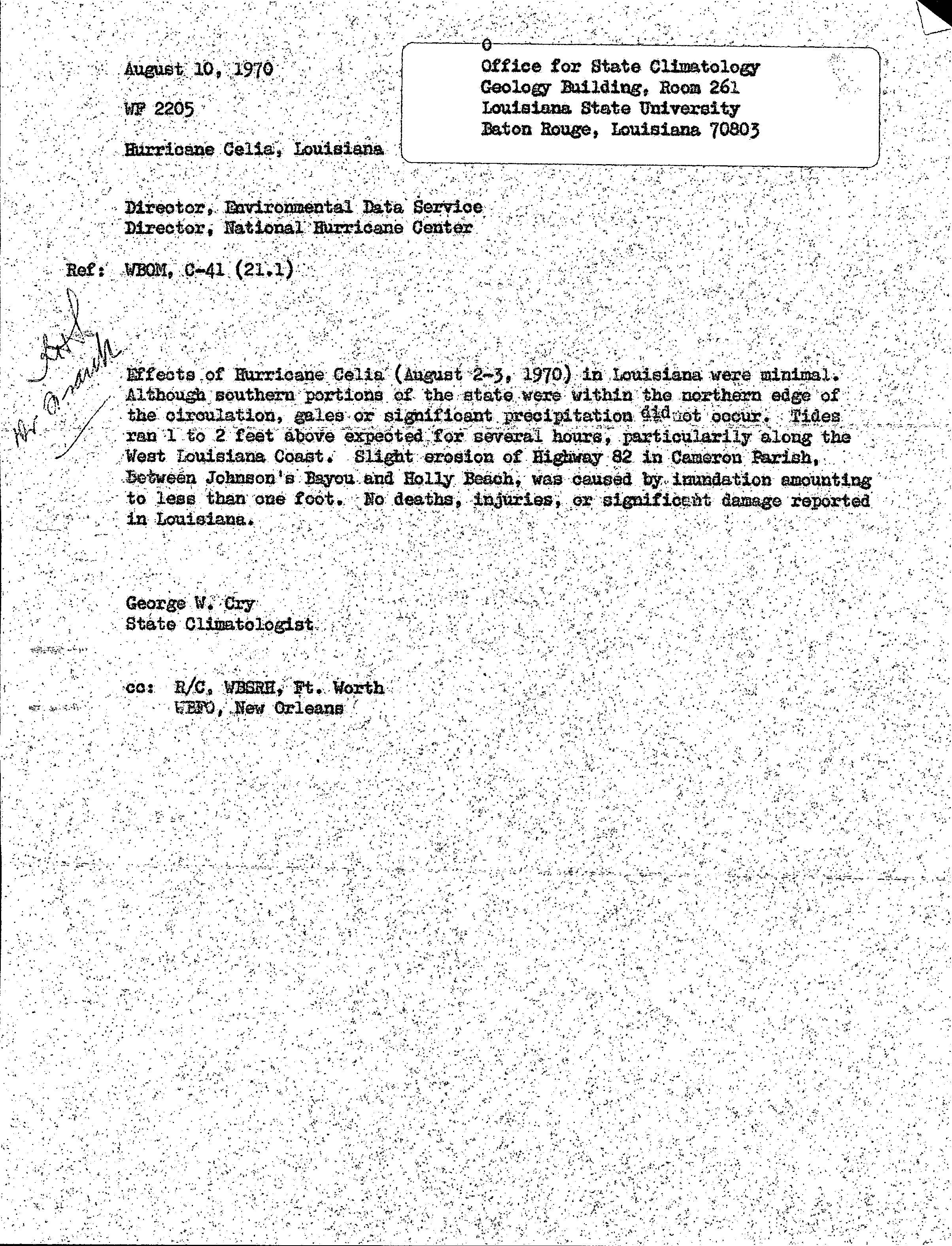
While crossing the Gulf of Mexico, Celia produced tides 1 to 2 feet (0.30 to 0.61 m) above normal on the southwestern coast of Louisiana. As a result, slight erosion of Louisiana Highway 82 occurred in Cameron Parish between Johnson Bayou and Holly Beach. No damage or fatalities were reported in that state.[34] After dissipating, the remnants of Celia produced up to 2 inches (51 mm) of rain in New Mexico, though no other impacts in the state are known.[5]
Aftermath
Following the storm, then-President of the United StatesRichard Nixon declared seven counties in Texas as disaster areas – Aransas, Bee, Jim Wells, Live Oak, Nueces, Refugio, and San Patricio – allowing affected residents to be eligible for federal relief.[35] Immediately, then-Governor of TexasPreston Smith sent National Guardsmen to the area to patrol and assist with recovery.[36] About a week after the storm, Governor Smith stated that the most urgent need was financial assistance, and designated the American Red Cross as the official relief agency. The American Red Cross chapters in Colbert and Lauderdale counties in Alabama announced that they were accepting donations to send to southern Texas.[37]
In Corpus Christi, officials applied to pollution control officers for permission to burn 1,300,000 cubic yards (990,000 m3) of debris.[36] The University of Corpus Christi (UCC) suffered so much damage that repairs were not affordable. In May 1971, the Texas Legislature passed a bill to establish a Texas A&I campus in Corpus Christi. Two years later, after local residents raised approximately $1.8 million to support the school, the UCC transferred its properties to Texas A&I University (now known as Texas A&M University-Corpus Christi).[38]
In addition, most homeowners insurance policies refused to write insurance for areas considered to be "high risk" along the Texas coast, prompting the state government to form the Texas Catastrophe Property Insurance Association, now known as the Texas Windstorm Insurance Association. Today, TWIA offers coverage to the 14 coastal counties of Texas and a small portion of Harris County near Houston, Texas.[39]
Due to the severity of damage caused by the hurricane, the National Hurricane Center retired the name Celia following the 1970 season, and it will never be used again for another Atlantic tropical cyclone.[40] It was replaced with Carmen for the 1974 season.[41]
^The position of Celia's Category 4 peak is not depicted in this graphic as it is an asynoptic point (i.e. not at the 6-hour intervals of all other points) occurring at 21:00 UTC August 3, the time of Texas landfall.
^ abcdRobert H. Simpson (1970-03-14). Preliminary Report Celia. National Hurricane Center (Report). Miami, Florida: National Oceanic and Atmospheric Administration. p. 2. Retrieved 2013-10-13.
^ abcdeRobert H. Simpson (1970-03-14). Preliminary Report Celia. National Hurricane Center (Report). Miami, Florida: National Oceanic and Atmospheric Administration. p. 3. Retrieved 2013-10-13.
^ abCelia's Later Life(JPG). National Hurricane Center (Report). Miami, Florida: National Oceanic and Atmospheric Administration. 1970. Retrieved 2013-02-08.
^Robert H. Simpson (1970-03-14). Preliminary Report Celia. National Hurricane Center (Report). Miami, Florida: National Oceanic and Atmospheric Administration. p. 4. Retrieved 2013-10-13.
^Preliminary Report Celia. National Hurricane Center (Report). Miami, Florida: National Oceanic and Atmospheric Administration. 1970. p. 5. Retrieved 2013-05-08.
^Preliminary Report Celia. National Hurricane Center (Report). Miami, Florida: National Oceanic and Atmospheric Administration. 1970. p. 8. Retrieved 2013-05-08.
^Preliminary Report Celia. National Hurricane Center (Report). Miami, Florida: National Oceanic and Atmospheric Administration. 1970. p. 9. Retrieved 2013-05-08.
^"Hurricane Report (Amistad, Texas)"(JPG). National Hurricane Center. Del Rio, Texas: National Oceanic and Atmospheric Administration. 1970-08-05. Retrieved 2013-02-08.
^Robert H. Herndon (1970-08-13). Hurricane Report (Aransas Pass, Texas)(JPG). National Hurricane Center (Report). Aransas Pass, Texas: National Oceanic and Atmospheric Administration. Retrieved 2013-02-08.
^Maurice Adams (1970-08-05). Hurricane Report (Artesia Wells, Texas)(JPG). National Hurricane Center (Report). Artestia Well, Texas: National Oceanic and Atmospheric Administration. Retrieved 2013-02-08.
^Bruno E. Bluhm (1970-08-07). Hurricane Report (Austwell, Texas)(PDF). National Hurricane Center (Report). Austwell, Texas: National Oceanic and Atmospheric Administration. Retrieved 2013-02-08.
^John B. Holdsworth (1970-08-15). Hurricane Report (Crystal City, Texas)(JPG). National Hurricane Center (Report). Crystal City, Texas: National Oceanic and Atmospheric Administration. Retrieved 2013-02-08.
^Shreves C. Goodwin (1970-08-05). Hurricane Report (Del Rio, Texas)(JPG). National Hurricane Center (Report). Del Rio, Texas: National Oceanic and Atmospheric Administration. Retrieved 2013-02-08.
^Shreves C. Goodwin (August 5, 1970). "Tropical Storm Data". Weather Bureau. Del Rio, Texas: National Oceanic and Atmospheric Administration; National Hurricane Center. Retrieved July 26, 2014.
^Kathryn S. Dewoody (1970-08-06). "Hurricane Report (Dilley, Texas)". National Hurricane Center. Dilly, Texas: National Oceanic and Atmospheric Administration. Retrieved 2013-02-08.
^Alonzo Garcia (1970-08-08). Hurricane Report (Eagle Pass, Texas)(JPG). National Hurricane Center (Report). Eagle Pass, Texas: National Oceanic and Atmospheric Administration. Retrieved 2013-02-08.
^Brooks M. Schley (1970-08-05). Hurricane Report (George West, Texas)(JPG). National Hurricane Center (Report). George West, Texas: National Oceanic and Atmospheric Administration. Retrieved 2013-02-08.
^Hurricane Report (Gregory, Texas)(JPG). National Hurricane Center (Report). Gregory, Texas: National Oceanic and Atmospheric Administration. 1970-08-10. Retrieved 2013-02-08.
^Jack R. Skiles (1970-08-07). Hurricane Report (Langtry, Texas)(JPG). National Hurricane Center (Report). Langtry, Texas: National Oceanic and Atmospheric Administration. Retrieved 2013-02-08.
^Thomas J. Jeter (1970-08-11). Hurricane Report (Refugio, Texas)(JPG). National Hurricane Center (Report). Refugio, Texas: National Oceanic and Atmospheric Administration. Retrieved 2013-02-08.
^Hurricane Report (Sandia, Texas)(JPG). National Hurricane Center (Report). Sandia, Texas: National Oceanic and Atmospheric Administration. 1970-08-14. Retrieved 2013-02-08.
^Hurricane Report (Taft, Texas)(JPG). National Hurricane Center (Report). Taft, Texas: National Oceanic and Atmospheric Administration. 1970-08-10. Retrieved 2013-02-08.
^Hurricane Report (Tilden, Texas)(JPG). National Hurricane Center (Report). Tilden, Texas: National Oceanic and Atmospheric Administration. 1970-08-07. Retrieved 2013-02-08.
^Jack Carper (1970-08-05). Hurricane Report (Uvalde, Texas)(JPG). National Hurricane Center (Report). Uvalde, Texas: National Oceanic and Atmospheric Administration. Retrieved 2013-05-08.
^Paul Brier (1970-08-06). Hurricane Report (Yoakum, Texas)(JPG). National Hurricane Center (Report). Yoakum, Texas: National Oceanic and Atmospheric Administration. Retrieved 2013-05-08.
^Preliminary Report Celia. National Hurricane Center (Report). Miami, Florida: National Oceanic and Atmospheric Administration. 1970. p. 6. Retrieved 2013-05-08.
^George W. Cry (1970-08-10). Hurricane Celia, Louisiana(JPG). Louisiana State University (Report). Baton Rouge, Louisiana: National Oceanic and Atmospheric Administration, National Hurricane Center. Retrieved 2012-04-11.
^National Hurricane Operations Plan(PDF) (Report). Washington, D.C.: NOAA Office of the Federal Coordinator for Meteorological Services and Supporting Research. June 1974. p. 103. Retrieved February 16, 2024.
Сельское поселение России (МО 2-го уровня)Новотитаровское сельское поселение Флаг[d] Герб 45°14′09″ с. ш. 38°58′16″ в. д.HGЯO Страна Россия Субъект РФ Краснодарский край Район Динской Включает 4 населённых пункта Адм. центр Новотитаровская Глава сельского посел…
جزء من سلسلة مقالات حولالإسلام حسب البلد الإسلام في إفريقيا أنغولا بنين بوتسوانا بوركينا فاسو بوروندي الكاميرون الرأس الأخضر أفريقيا الوسطى نشاد الجزائر جزر القمر الكونغو الديمقراطية الكونغو ساحل العاج جيبوتي مصر غينيا الاستوائية إريتريا إثيوبيا الغابون غامبيا غانا غين�…
DC Comics supervillain The Cheetah redirects here. For other uses, see Cheetah (disambiguation). Comics character CheetahBarbara Ann Minerva as the Cheetah from a splash page of Wonder Woman #750 (January 2020). Art by Nicola Scott.Publication informationPublisherDC ComicsFirst appearance Rich:Wonder Woman #6 (Autumn 1943) Domaine:Wonder Woman #274 (December 1980) Minerva:Wonder Woman (vol. 2) #7 (August 1987) Ballesteros:Wonder Woman (vol. 2) #170 (July 2001) Created by Rich:William Moulton Mar…
2004 Spanish film directed by Pedro Almodóvar Bad EducationTheatrical release posterSpanishLa mala educación Directed byPedro AlmodóvarWritten byPedro AlmodóvarProduced by Agustín Almodóvar Pedro Almodóvar Starring Gael García Bernal Fele Martínez Daniel Giménez Cacho Lluís Homar Francisco Boira Javier Cámara CinematographyJosé Luis AlcaineEdited byJosé SalcedoMusic byAlberto IglesiasProductioncompanyEl DeseoDistributed byWarner SogefilmsRelease date 19 March 2004 (2…
Comando carabinieri per la tutela forestale e parchiDescrizione generaleAttiva2017 - oggi Nazione Italia Servizio Arma dei Carabinieri TipoSpecialità Ruolo Polizia forestale Polizia ambientale Polizia giudiziaria Polizia amministrativa Protezione civile Guarnigione/QGRoma ColoriGrigioverde Parte di Comando unità forestali, ambientali e agroalimentari Reparti dipendenti14 Comandi Regione Carabinieri Forestale Nucleo Informativo Antincendio Boschivo ComandantiComandante attualeGen. div…
18th-century Spanish naval officer, scientist, and colonial administrator The Most ExcellentAntonio de UlloaFRS FRSA KOSPosthumous portrait by Andrés Cortés (1856)BornAntonio de Ulloa y de la Torre-Giralt(1716-01-12)12 January 1716Seville, SpainDied3 July 1795(1795-07-03) (aged 79)Isla de León, SpainNationalitySpanishAlma materReal Compañía de Guardias Marinas (Spanish Naval Academy)SpouseFrancisca Ramírez de LaredoScientific careerFieldsAstronomy, metallurgy, natural history 1st…
Species of mammal Eastern cottontail[1] Male Female Conservation status Least Concern (IUCN 3.1)[2] Secure (NatureServe)[3] Scientific classification Domain: Eukaryota Kingdom: Animalia Phylum: Chordata Class: Mammalia Order: Lagomorpha Family: Leporidae Genus: Sylvilagus Species: S. floridanus Binomial name Sylvilagus floridanus(J. A. Allen, 1890) Eastern cottontail range (includes range of S. holzneri) The eastern cottontail (Sylvilagus floridanus) is a…
Era in professional wrestling In March 2010, professional wrestling promotion Total Nonstop Action Wrestling (TNA) moved their weekly television program, Impact!, from airing on Thursdays to airing Monday nights. In doing so, TNA placed Impact! in direct competition with World Wrestling Entertainment's (WWE) flagship program Monday Night Raw. It drew comparisons to the Monday Night War, in which defunct wrestling promotion World Championship Wrestling (WCW) program Nitro went head-to-head with R…
Indian actor and film producer (1928–2001) Sivaji GanesanSivaji GanesanBornVettaithidal Chinnaiya Manrayar Ganesamoorthy(1928-10-01)1 October 1928[1][2][3][4][5]Vettaithidal[6]Thanjavur district Madras Presidency, British India (now Tamil Nadu, India)Died21 July 2001(2001-07-21) (aged 72)Chennai, Tamil Nadu, IndiaOther namesNadigar ThilagamSimmakuralonOccupationsActorFilm producerPoliticianPolitical partyTamizhaga Munnetra Munnani (1988…
Railway station in Hebei, China This article relies largely or entirely on a single source. Relevant discussion may be found on the talk page. Please help improve this article by introducing citations to additional sources.Find sources: Tanghai South railway station – news · newspapers · books · scholar · JSTOR (March 2021) Tanghai South唐海南General informationLocationCaofeidian District, Tangshan, HebeiChinaCoordinates39°13′1.88″N 118°35′4.28…
Govering body for competition climbing International Federation of Sport ClimbingFormation27 January 2007 (2007-01-27)TypeSports federationHeadquartersTurin, ItalyMembership 98 member federationsPresidentMarco Maria ScolarisWebsiteIFSC-Climbing.org The International Federation of Sport Climbing (IFSC) is the international governing body for the sport of competition climbing, which consists of the disciplines lead climbing, bouldering, and speed climbing. Charter The IFSC describes…
1967 studio album by Van MorrisonBlowin' Your Mind!Studio album by Van MorrisonReleasedSeptember 1967Recorded28–29 March 1967GenreRock, R&B, blue-eyed soul, bluesLength35:32LabelBangProducerBert BernsVan Morrison chronology Blowin' Your Mind!(1967) Astral Weeks(1968) Singles from Blowin' Your Mind! Brown Eyed Girl b/w Goodbye Baby Ro Ro Rosey b/w Chick-A-Boom Spanish Rose b/w Midnight Special Professional ratingsReview scoresSourceRatingAllmusic[1]Tom HullA[2] Blowi…
В списке объектов всемирного наследия ЮНЕСКО в Таджикистане значатся 2 наименования (на 2015 год), что составляет 0,2 % от общего числа (1199 на 2023 год). В список включены 2 объекта: 1 — по культурному и 1 — по природному критериям, соответственно. Кроме этого, по состоянию на 2015 го…
Voce principale: Unione Sportiva Salernitana 1919. Salernitana Calcio 1919Stagione 2006-2007Sport calcio Squadra Salernitana Allenatore Raffaele Novelli poi Gianfranco Bellotto Presidente Antonio Lombardi Serie C110º posto Coppa ItaliaPrimo Turno Coppa Italia CPrimo Turno Maggiori presenzeCampionato: Soligo (33) Miglior marcatoreCampionato: E. Ferraro (15) StadioStadio Arechi 2005-2006 2007-2008 Si invita a seguire il modello di voce Questa pagina raccoglie i dati riguardanti la Salernitan…


")
")


