Hat Samran district

Hat Samran
หาดสำราญ
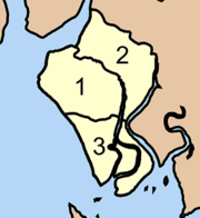
District location in Trang province
Coordinates: 7°14′24″N 99°34′36″E / 7.24000°N 99.57667°E / 7.24000; 99.57667
CountryThailand
ProvinceTrang
SeatHat Samran
Area
 • Total
224.0 km2 (86.5 sq mi)
Population
 (2005)
 • Total
15,550
 • Density69.4/km2 (180/sq mi)
Time zoneUTC+7 (ICT)
Postal code92120
Geocode9210

Hat Samran (Thai: หาดสำราญ, pronounced [hàːt sǎm.rāːn]) is a district (amphoe) in the southern part of Trang province, Thailand.

History

The minor district (king amphoe) Hat Samran was established on 30 April 1994 by splitting it from Palian district.[1]

In 2007 all 81 minor districts were upgraded to full districts.[2] With publication in the Royal Gazette on 24 August 2007 the upgrade became official.[3]

Administration

The district is divided into three sub-districts (tambons), which are further subdivided into 21 villages (mubans). There are no municipal (thesaban) areas, and three tambon administrative organizations (TAO).

No. Name Thai name Villages Pop.
1. Hat Samran หาดสำราญ 11 8,389
2. Ba Wi บ้าหวี 4 2,877
3. Tase ตะเสะ 6 4,284
 Map of districts

References

  1. ^ ประกาศกระทรวงมหาดไทย เรื่อง แบ่งเขตท้องที่อำเภอปะเหลียน จังหวัดตรัง ตั้งเป็นกิ่งอำเภอหาดสำราญ (PDF). Royal Gazette (in Thai). 111 (42 ง): 29. May 26, 1994. Archived from the original (PDF) on July 18, 2011.
  2. ^ แถลงผลการประชุม ครม. ประจำวันที่ 15 พ.ค. 2550 (in Thai). Manager Online. Archived from the original on 2011-05-16. Retrieved 2007-09-12.
  3. ^ พระราชกฤษฎีกาตั้งอำเภอฆ้องชัย...และอำเภอเหล่าเสือโก้ก พ.ศ. ๒๕๕๐ (PDF). Royal Gazette (in Thai). 124 (46 ก): 14–21. August 24, 2007. Archived from the original (PDF) on September 30, 2007.