Gozo Channel

Gozo Channel
Il-Fliegu t'Ghawdex
The whole path of the Gozo ferry, seen from Ramla Bay, Marfa. To the left Ċirkewwa terminal, to the right Mġarr harbour on Gozo
The Gozo Channel
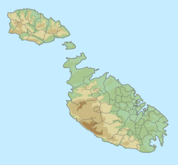
Map of the Maltese archipelago. A red dot placed next to Comino, between Malta and Gozo, shows the area of the Gozo Channel.
Gozo Channel
Location of the Gozo Channel in Malta
LocationBetween Gozo and Malta (island)
GroupMediterranean Sea
Coordinates36°00′N 14°19′E / 36.00°N 14.31°E / 36.00; 14.31
TypeSaline
Max. length5.5 km (3.4 mi)
Max. width6.7 km (4.2 mi)
Surface area27.4 km2 (10.6 sq mi)
Max. depth26 m (85 ft)
Islands4

The Gozo Channel is short stretch of Mediterranean Sea separating the Maltese island of Gozo from the northern tip of Malta.[1]

It is about 7 km (4.3 mi) long and varies in width from 6.7 km (4.2 mi) at its widest to 4.5 km (2.8 mi) at its northeastern end. At the centre of the channel are the two islands of Comino (inhabited) and Cominotto. The channel serves as a sea route link between the two islands with a ferry service run by Gozo Channel Line running all year round[2] from the ports of Mġarr Harbour and Ċirkewwa.[3]

References

  1. ^ "Gozo – The gap can be bridged: by Dr. Franco Mercieca". Gozo News. 2011-02-05. Retrieved 2021-12-30.
  2. ^ "Gozo Channel Ferries, timetable". Archived from the original on 2012-08-14. Retrieved 2012-03-01.
  3. ^ "Gozo Channel". Gozo Channel. Archived from the original on 2021-12-30. Retrieved 2021-12-30.