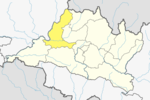
Gajuri Rural Municipality

Gajuri
गजुरी (Nepali)
Rural Municipality in Nepal
Gajuri is located in Nepal
Gajuri
Gajuri
Location in Nepal
Coordinates: 27°46′N 84°51′E / 27.77°N 84.85°E / 27.77; 84.85
CountryNepal
Development RegionCentral
ZoneBagmati
DistrictDhading
ProvinceProvince No. 3
Rural MunicipalityGajuri
Government
 • ChairpersonMr. Ganesh Lal Shrestha (CPN (Maoist Center))
 • Vice-chairpersonMrs. Sarmila Bishural (Nepali Congress)
Area
 • Total
138.66 km2 (53.54 sq mi)
Population
 (2017)[1]
 • Total
27,084
 • Density200/km2 (510/sq mi)
 • Religions
Hindu Muslim Buddhist
Languages
 • LocalNepali, Newar language, Tamang, Gurung, Magar
Time zoneUTC+5:45 (NST)
Postal Code
45112
Area code010
Literacy RateIncrease 64.28% High
Websitehttp://gajurimun.gov.np

Gajuri(Nepali: गजुरी ; gajuri) is a Gaupalika (Nepali: गाउपालिका ; gaupalika)[2] (Formerly: village development committee) in Dhading District in the Bagmati Zone of central Nepal. It has a literacy rate of 64.28% (70.30% male and 58.41% female). The city hosts as one of the city with highest literacy rate in the Dhading district. The local body was formed by merging three VDCs namely Gajuri, Pida, Nepal, Kiranchok.[3]

At the time of the 2011 Nepal census it had a population of 10,035 including 4,968 males and 5,067 females, being one of the most populated city in the district. The average household size was 4.51. Besides, it had 2,223 houses in this area.[4] According to the report, out of 2,223 houses, around 1,884 had at least one facility like Radio, Television, Internet, etc.

During the collection of voters data for 2017 Nepalese local elections, the population of Gajuri was calculated to be 27,084.

Rural Municipality

Gajuri was declared as Rural Municipality on March 10, 2017. The formation of Rural Municipality led to local level elections on May 14, 2017. Out of a population of 27,084, there were 14,169 total eligible voters. CPN (UML) won positions for both Chairperson and Vice-Chairperson with a vote count of 4,336 and 4,214 respectively.[1]

Transportation

Gajuri is connected to Kathmandu to the east and Malekhu to the west by Prithvi Highway.

Geography

Gajuri lies at the North-Western part of Dhading District to the south of Trishuli River and covers an area of 138.66 km2. The average altitude of Gajuri is 547 metres (1796 ft) above sea level.[5]

Gajuri in 1989 AD (2046 B.S)

Demographics

Per 2011 Census, the total population of Gajuri was 10,035 out of which 4,968 were male and 5,067 female in 2,223 households. Average family size was 4.51[6]

Population

By Age

Sex[7] Total 00 - 04 05 - 09 10 - 14 15 - 19 20 - 24 25 - 29 30 - 34 35 - 39 40 - 44 45 - 49 50 - 54 55 - 59 60 - 64 65 - 69 70 - 74 75 +
Both Sex 10,035 1,001 1,261 1,346 1,148 878 796 604 556 533 408 399 286 245 184 146 244
Male 4,968 507 645 677 545 382 365 290 269 273 212 217 149 131 95 79 132
Female 5,067 494 616 669 603 496 431 314 287 260 196 182 137 114 89 67 112

By Literacy Rate

Sex[8] Pop. aged 5 and 5+ Who can Read & Write Who can Read only Who can't read & write Not Stated Literacy Rate
Both Sex 9,034 5,807 329 2,893 5 64.28
Male 4,461 3,136 171 1,152 2 70.30
Female 4,573 2,671 158 1,741 3 58.41

By Caste

Caste/Ethnicity[9] Total Male Female
All Caste 10,035 4,968 5,067
Chhetree 1,301 620 681
Brahman - Hill 1,776 878 898
Magar 525 244 281
Tharu 23 13 10
Tamang 2,229 1,120 1,109
Newar 646 315 331
Musalman 75 52 23
Kami 597 298 299
Gurung 101 46 55
Damai/Dholi 375 195 180
Thakuri 18 8 10
Sarki 591 288 303
Sanyasi/Dashnami 74 41 33
Gharti/Bhujel 44 20 24
Majhi 17 10 7
Chepang/Praja 1,405 711 694
Ghale 181 80 101
Others 57 29 28

Hospitals

  • Gajuri Primary Health Centre
  • Gajuri Hospital Pvt. Ltd[10]

Schools

  • Adarsha Secondary School
  • Munal Academy
  • Pawil Himal Academy

College

  • Adarsha Multiple Campus


Bank/ATM

  • राष्ट्रिय वाणिज्य बैंक
  • प्रभु बैंक लिमिटेड
  • कृषि विकास बैंक लिमिटेड
  • एनआइसी एसिया बैंक
  • नबिल बैंक
  • माछापुच्छे बैंक लिमिटेड
  • National Banijya Bank
  • Prabhu Bank Limited
  • Krishi Vikas Bank Limited
  • NIC Asia Bank
  • Nabil Bank
  • Machhapuchhe Bank Limited

See also

References

  1. ^ a b "Local Elections 2074 - Election Results Overview - Dhading - Gajuri". Retrieved 2017-06-02.
  2. ^ "यसरी २ नगर र ११ गाउँपालिकामा बाँडिनेभयो धादिङलाई (स्पष्ट नक्सासहित)". Sajhapost. Nov 11, 2016. Archived from the original on July 3, 2019. Retrieved March 9, 2017.
  3. ^ Nepal, MOFALD. "Final District 1-75 Corrected Last for RAJPATRA" (PDF). mofald.gov.np. Ministry of Federal Affairs and Local Development (Nepal). p. 166. Retrieved June 2, 2017.
  4. ^ "Households by ownership of house/housing unit In use" (PDF). Nepal's Village Development Committees. Central Bureau of Statistics. Archived from the original (PDF) on 2018-02-19. Retrieved 2016-07-13.
  5. ^ ElevationMap.net. "Elevation of Gajuri with altitude and height". elevationmap.net. Retrieved 2017-06-04.
  6. ^ "A detailed Report" (PDF). Nepal's Village Development Committees. Central Bureau of Statistics. Archived from the original (PDF) on 2018-02-19. Retrieved 2016-07-13.
  7. ^ "Population Distribution of Dhading, Page 28" (PDF). Nepal's Village Development Committees. Central Bureau of Statistics. Archived from the original (PDF) on 2018-02-19. Retrieved 2016-07-13.
  8. ^ "Population Distribution of Dhading, Page 63" (PDF). Nepal's Village Development Committees. Central Bureau of Statistics. Archived from the original (PDF) on 2018-02-19. Retrieved 2016-07-13.
  9. ^ "Population Distribution of Dhading, Page 37" (PDF). Nepal's Village Development Committees. Central Bureau of Statistics. Archived from the original (PDF) on 2018-02-19. Retrieved 2016-07-13.
  10. ^ "Hospitals in Gajuri". Nepalyp. Retrieved 6 July 2016.