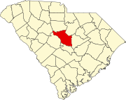
Census-designated place in South Carolina, United States
Gadsden is a census-designated place in Richland County , South Carolina , United States. The population was 1,632 at the 2010 census .[ 5] Columbia, South Carolina metropolitan area .
History
The John J. Kaminer House , Magnolia , Oakwood , and Richland Presbyterian Church are listed on the National Register of Historic Places .[ 6]
Geography
Gadsden is located at latitude 33.846 North and longitude 80.766 West. The elevation is 148 feet (45 m) above sea level.[ 7] 2 ), of which 0.008 square miles (0.02 km2 ), or 0.06%, is water.[ 5] 48 and 769 .
Demographics
Historical population
Census Pop. Note %± 2020 1,301 —
2020 census
As of the 2020 United States census , there were 1,301 people, 546 households, and 425 families residing in the Town.
References
^ "ArcGIS REST Services Directory" . United States Census Bureau. Retrieved October 15, 2022 .^ a b U.S. Geological Survey Geographic Names Information System: Gadsden, South Carolina ^ "Census Population API" . United States Census Bureau. Retrieved October 15, 2022 .^ "U.S. Census website" . United States Census Bureau . Retrieved January 31, 2008 .^ a b "Geographic Identifiers: 2010 Demographic Profile Data (G001): Gadsden CDP, South Carolina" . U.S. Census Bureau, American Factfinder. Archived from the original on February 12, 2020. Retrieved January 14, 2013 .^ "National Register Information System" . National Register of Historic Places National Park Service . July 9, 2010.^ "Gadsden, South Carolina ". HomeTownLocator.
^ "Census of Population and Housing" . Census.gov. Retrieved June 4, 2016 .^ "Explore Census Data" . data.census.gov . Retrieved December 13, 2021 .

