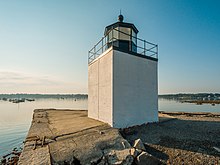
Derby Wharf Light

Derby Wharf Light
Map
LocationSalem, Massachusetts
Coordinates42°30′59.6″N 70°53′0.9″W / 42.516556°N 70.883583°W / 42.516556; -70.883583
Tower
Constructed1871
ConstructionBrick
Automated1970s
Height4 m (13 ft) Edit this on Wikidata
ShapeSquare
MarkingsWhite Black
HeritageNational Register of Historic Places listed place Edit this on Wikidata
Fog signalnone
Light
First lit1871
Deactivated1977–1983
Focal height25 feet (7.6 m)
Lens5th order Fresnel lens 1871-1906
4th order 1906-1910
6th order 1910-1970s
Solar-powered optic (current)
Range4 nautical miles (7.4 km; 4.6 mi)
CharacteristicFl R 6sec
Derby Wharf Light Station
MPSLighthouses of Massachusetts TR
NRHP reference No.87001466[1]
Added to NRHPJune 15, 1987

Derby Wharf Light Station is a historic lighthouse on Derby Wharf in Salem, Massachusetts that is within the Salem Maritime National Historic Site.[2][3]

It was built in 1871 and added to the National Register of Historic Places in 1987.[3][1] The United States Coast Guard Light List[2] description is "White square tower. Maintained by the U.S. Park Service". The actual light is 25 feet (7.6 m) above Mean High Water. Its red light is visible for 4 nautical miles (7.4 km; 4.6 mi).

History

The Light Station was originally built in 1871 and used an oil lamp shining through a Fresnel lense. For many years, Derby Wharf Light had one of only 17 sixth-order Fresnel lenses in the United States. Today, the light is solar powered, and the light is a red flash every six seconds.

See also

References

  1. ^ a b "National Register Information System". National Register of Historic Places. National Park Service. April 15, 2008.
  2. ^ a b Light List, Volume I, Atlantic Coast, St. Croix River, Maine to Shrewsbury River, New Jersey (PDF). Light List. United States Coast Guard. 2010. p. 83.
  3. ^ a b "Historic Light Station Information and Photography: Massachusetts". United States Coast Guard Historian's Office. Archived from the original on 2017-05-01.