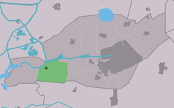
De Veenhoop

De Veenhoop
De Feanhoop
Village
Flag of De Veenhoop
Coat of arms of De Veenhoop
Location in Smallingerland municipality
De Veenhoop is located in Friesland
De Veenhoop
De Veenhoop
Location in the Netherlands
De Veenhoop is located in Netherlands
De Veenhoop
De Veenhoop
De Veenhoop (Netherlands)
Coordinates: 53°5′49″N 5°56′59″E / 53.09694°N 5.94972°E / 53.09694; 5.94972
CountryNetherlands Netherlands
ProvinceFriesland Friesland
MunicipalitySmallingerland Smallingerland
Area
 • Total
9.75 km2 (3.76 sq mi)
Elevation−1.0 m (−3.3 ft)
Population
 (2021)[1]
 • Total
260
 • Density27/km2 (69/sq mi)
Postal code
9215[1]
Dialing code0512

De Veenhoop (West Frisian: De Feanhoop) is a village in Smallingerland municipality in the province of Friesland, the Netherlands. It had a population of around 245 in January 2017.[3]

History

The village was first mentioned between 1851 and 1855 as De Veenhoop, and means "place where peat is excavated".[4] De Veenhoop developed in the late 19th century at the intersection of the Polderhoofdkanaal and the Grietmansrak as a peat excavation village.[5]

Nature

The Petgatten de Feanhoop is a nature area on the edge of De Alde Feanen National Park. The 200 hectares (490 acres) area of lakes and swamp forest attracted a large variety of bird life, and is a protected area since 1996.[6][5]

References

  1. ^ a b c "Kerncijfers wijken en buurten 2021". Central Bureau of Statistics. Retrieved 3 April 2022.
  2. ^ "Postcodetool for 9215MA". Actueel Hoogtebestand Nederland (in Dutch). Het Waterschapshuis. Retrieved 3 April 2022.
  3. ^ Bevolkingscijfers Archived 2017-11-07 at the Wayback Machine - Smallingerland
  4. ^ "Veenhoop - (geografische naam)". Etymologiebank (in Dutch). Retrieved 3 April 2022.
  5. ^ a b "De Veenhoop". Plaatsengids (in Dutch). Retrieved 3 April 2022.
  6. ^ "Petgatten de Feanhoop". It Fryske Gea (in Dutch). Retrieved 3 April 2022.

Media related to De Veenhoop at Wikimedia Commons