Danxia Town

Danxia
丹霞镇
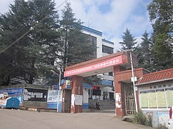
The government building of Danxia Town.
Map
Coordinates: 25°41′10″N 104°36′49″E / 25.68611°N 104.61361°E / 25.68611; 104.61361 Map
CountryPeople's Republic of China
ProvinceGuizhou
Prefecture-level cityLiupanshui
County-level cityPanzhou
Area
 • Total
175.35 km2 (67.70 sq mi)
Population
 (2017)
 • Total
48,962
 • Density280/km2 (720/sq mi)
Time zoneUTC+08:00 (China Standard)
Postal code
561601
Area code0858
Chinese name
Simplified Chinese
Traditional Chinese
Transcriptions
Standard Mandarin
Hanyu PinyinDānxiá Zhèn
A hospital in Banqiao Community.

Danxia (Chinese: 丹霞镇) is a town in Panzhou, Guizhou, China.[1] As of the 2017 census it had a population of 48,962 and an area of 175.35-square-kilometre (67.70 sq mi).

History

On June 4, 2015, Shuitang Town (水塘镇) and some parts of Banqiao Town (板桥镇) were merged to form a new town named "Danxia".

Administrative division

As of December 2015, the town is divided into 14 villages and 1 community:

  • Banqiao Community (板桥社区)
  • Sanzhai (三寨村)
  • Lijiawan (李家湾村)
  • Meizichong (梅子冲村)
  • Beiyinjing (背阴箐村)
  • Zhaoguantun (赵官屯村)
  • Shunjutun (顺居屯村)
  • Shuitang (水塘村)
  • Guoguan (郭官村)
  • Huangnitian (黄泥田村)
  • Qiansuo (前所村)
  • Mulong (木龙村)
  • Taoyuan (桃园村)
  • Huangba (荒坝村)
  • Waishanlan (外山岚村)
  • Lishanlan (里山岚村)
  • Tiechang (铁厂村)
  • Hetaoshu (核桃树村)
  • Shadipo (沙地坡村)
  • Cangpukeng (苍蒲坑村)
  • Pingchuan (坪川村)

Economy

The town's economy is based on nearby coal reserves and agricultural resources. Potatoes are the main crop.

Transportation

The S77 Expressway and Provincial Highway S212 pass across the town north to south.

Attractions

The Huguo Temple is a Buddhist temple in the town.

See also

References

  1. ^ Luan Xiaolin (栾小琳) (17 April 2019). 盘州市丹霞镇开展毒品预防教育进景区宣传活动. xinhuanet (in Chinese). Archived from the original on 17 April 2019. Retrieved 11 December 2019.