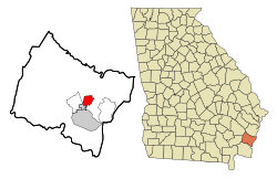
Place in Georgia, United States
Country Club Estates is an unincorporated community and census-designated place (CDP) in Glynn County , Georgia , United States. It is part of the Brunswick metropolitan statistical area . The population was 8,373 at the 2020 census ,[ 4]
Geography
Country Club Estates is located at 31°12′41″N 81°28′7″W / 31.21139°N 81.46861°W / 31.21139; -81.46861 [ 5] Mackay River . U.S. Route 17 passes through the center of the CDP, leading south 5 miles (8 km) into downtown Brunswick and north 12 miles (19 km) to Darien . The CDP extends north as far as Chapel Crossing Road west of US 17 and Yacht Drive east of US 17.
According to the United States Census Bureau , the CDP has a total area of 4.7 square miles (12.3 km2 ), of which 4.6 square miles (12.0 km2 ) is land and 0.1 square miles (0.3 km2 ), or 2.23%, is water.[ 6]
Demographics
Historical population
Census Pop. Note %± 1990 5,192 — 2000 7,594 46.3% 2010 8,545 12.5% 2020 8,373 −2.0%
Country Club Estates was first listed as a CDP in the 1990 U.S. Census .[ 18]
Country Club Estates, Georgia – Racial and ethnic composition Note: the US Census treats Hispanic/Latino as an ethnic category. This table excludes Latinos from the racial categories and assigns them to a separate category. Hispanics/Latinos may be of any race.
Race / Ethnicity (NH = Non-Hispanic )
Pop 2000[ 20]
Pop 2010[ 21]
Pop 2020[ 4]
% 2000
% 2010
% 2020
White alone (NH)
4,171
3,590
3,367
54.92%
42.01%
40.21%
Black or African American alone (NH)
2,940
3,934
3,636
38.71%
46.04%
43.43%
Native American or Alaska Native alone (NH)
23
19
20
0.30%
0.22%
0.24%
Asian alone (NH)
83
143
142
1.09%
1.67%
1.70%
Pacific Islander alone (NH)
10
45
42
0.13%
0.53%
0.50%
Some Other Race alone (NH)
10
20
36
0.13%
0.23%
0.43%
Mixed race or Multiracial (NH)
103
144
282
1.36%
1.69%
3.37%
Hispanic or Latino (any race)
254
650
848
3.34%
7.61%
10.13%
Total
7,594
8,545
8,373
100.00%
100.00%
100.00%
As of the 2020 United States census , there were 8,373 people, 3,319 households, and 1,869 families residing in the CDP.
Education
The community's public schools are operated by the Glynn County School System .[ 22]
Zoned schools serving sections of the CDP include:
References
^ "2020 U.S. Gazetteer Files" . United States Census Bureau. Retrieved December 18, 2021 .^ "U.S. Census website" . United States Census Bureau . Retrieved January 31, 2008 .^ "US Board on Geographic Names" . United States Geological Survey . October 25, 2007. Retrieved January 31, 2008 .^ a b c "P2: Hispanic or Latino, and Not Hispanic or Latino by Race – 2020: DEC Redistricting Data (PL 94-171) - Country Club Estates CDP, Georgia" . United States Census Bureau.^ "US Gazetteer files: 2010, 2000, and 1990" . United States Census Bureau . February 12, 2011. Retrieved April 23, 2011 .^ "Geographic Identifiers: 2010 Demographic Profile Data (G001): Country Club Estates CDP, Georgia" . American Factfinder . U.S. Census Bureau. Retrieved November 22, 2016 .[dead link ] ^ "Decennial Census of Population and Housing by Decade" . United States Census Bureau .^ "1870 Census of Population - Georgia - Population of Civil Divisions less than Counties" (PDF) . United States Census Bureau . 1870.^ "1880 Census of Population - Georgia - Population of Civil Divisions less than Counties" (PDF) . United States Census Bureau . 1880.^ "1910 Census of Population - Georgia" (PDF) . United States Census Bureau . 1910.^ "1930 Census of Population - Georgia" (PDF) . United States Census Bureau . 1930. pp. 251–256.^ "1940 Census of Population - Georgia" (PDF) . United States Census Bureau . 1940.^ "1950 Census of Population - Georgia" (PDF) . United States Census Bureau . 1950.^ "1960 Census of Population - Population of County Subdivisions - Georgia" (PDF) . United States Census Bureau . 1960.^ "1970 Census of Population - Population of County Subdivisions - Georgia" (PDF) . United States Census Bureau . 1970.^ "1980 Census of Population - Number of Inhabitants - Georgia" (PDF) . United States Census Bureau . 1980.^ "1990 Census of Population - Summary Social, Economic, and Housing Characteristics - Georgia" (PDF) . United States Census Bureau . 1990.^ a b "2000 Census of Population - General Population Characteristics - Georgia" (PDF) . United States Census Bureau . 2000.^ "2010 Census of Population - General Population Characteristics - Georgia" (PDF) . United States Census Bureau . 2010.^ "P004 Hispanic or Latino, and Not Hispanic or Latino by Race – 2000: DEC Summary File 1 – Chattanooga Valley CDP, Georgia" . United States Census Bureau.^ "P2: Hispanic or Latino, and Not Hispanic or Latino by Race – 2010: DEC Redistricting Data (PL 94-171) - Country Club Estates CDP, Georgia" . United States Census Bureau.^ "2010 CENSUS - CENSUS BLOCK MAP: Country Club Estates CDP, GA ." U.S. Census Bureau . Retrieved on March 13, 2019.
^ "Elementary School Zones Map Archived March 12, 2019, at the Wayback Machine ." Glynn County School System . Retrieved on March 13, 2019.
^ "Middle School Zones Map Archived 2019-03-12 at the Wayback Machine ." Glynn County School System . Retrieved on March 13, 2019. Detail maps: JMS [permanent dead link ] NMS Archived March 12, 2019, at the Wayback Machine .
^ "High School Zones Map Archived March 12, 2019, at the Wayback Machine ." Glynn County School System . Retrieved on March 13, 2019.

