Clifton, South Carolina

Clifton
Clifton is located in South Carolina
Clifton
Clifton
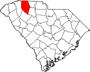
Location within the state of South Carolina
Coordinates: 34°59′10″N 81°49′13″W / 34.98611°N 81.82028°W / 34.98611; -81.82028
CountryUnited States
StateSouth Carolina
CountySpartanburg
Area
 • Total
1.14 sq mi (2.95 km2)
 • Land1.07 sq mi (2.78 km2)
 • Water0.07 sq mi (0.17 km2)
Elevation669 ft (204 m)
Population
 • Total
544
 • Density506.99/sq mi (195.80/km2)
Time zoneUTC-5 (Eastern (EST))
 • Summer (DST)UTC-4 (EDT)
ZIP codes
29324
FIPS code45083
GNIS feature ID2629821[2]

Clifton is a Census-designated place located in Spartanburg County in the U.S. State of South Carolina.[4] According to the 2010 United States Census, the population was 541.[5]

Geography

Clifton is located at 34°59′10″N 81°49′13″W / 34.98611°N 81.82028°W / 34.98611; -81.82028 (34.986051, -81.820395).[4] These coordinates place the CDP on the East side of the county, between the cities of Spartanburg and Cowpens.

According to the United States Census Bureau, the CDP has a total land area of 1.073  square miles (2.946  km2) and a total water area of 0.065  square mile (0.168  km2).[4]

Demographics

Historical population
CensusPop.Note
2020544
U.S. Decennial Census[6]

References

  1. ^ "ArcGIS REST Services Directory". United States Census Bureau. Retrieved October 15, 2022.
  2. ^ a b U.S. Geological Survey Geographic Names Information System: Clifton, South Carolina
  3. ^ "Census Population API". United States Census Bureau. Retrieved October 15, 2022.
  4. ^ a b c "US Gazetteer files: 2010, 2000, and 1990". United States Census Bureau. February 12, 2011. Retrieved April 23, 2011.
  5. ^ See "U.S. Census website". United States Census Bureau. Retrieved January 31, 2008. for population numbers and for municipality and CDP lists in the 2010 Census.
  6. ^ "Census of Population and Housing". Census.gov. Retrieved June 4, 2016.