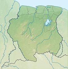
Cayana Airstrip

Cayana Airstrip

Kajana Airstrip
Summary
Airport typePublic
OperatorLuchtvaartdienst Suriname
LocationKajana, Suriname
Elevation AMSL360 ft / 110 m
Coordinates3°53′55″N 55°34′40″W / 3.89861°N 55.57778°W / 3.89861; -55.57778
Map
AAJ is located in Suriname
AAJ
AAJ
Location of airport in Suriname
Map
Runways
Direction Length Surface
m ft
07/25 500 1,640 grass
Sources: GCM[1] Google Maps[2]

Cayana Airstrip (IATA: AAJ, ICAO: SMCA) is an airstrip serving the villages around Kajana in the Sipaliwini District of Suriname. The runway is just west of Kajana, across the Suriname River.

Airlines and destinations

Airlines serving this airport are:

AirlinesDestinations
Blue Wing AirlinesCharter: Paramaribo–Zorg en Hoop[3]
Gum AirCharter: Paramaribo–Zorg en Hoop[4]
Hi-Jet Helicopter ServicesCharter: Paramaribo–Zorg en Hoop
United Air ServicesCharter: Paramaribo–Zorg en Hoop
Vortex Aviation SurinameCharter: Paramaribo–Zorg en Hoop

Accidents and incidents

  • On June 18, 1982, Cessna U206G (PZ-TAC) from Gonini Air Service was damaged at the Cayana airstrip. The pilot was Mr. Kuiper, who escaped serious injuries.[5]

See also

References