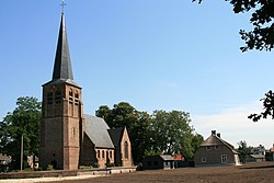
Capelle

Capelle
Village
Old St Willibrordus Church
Capelle is located in North Brabant
Capelle
Capelle
Location in the province of North Brabant in the Netherlands
Capelle is located in Netherlands
Capelle
Capelle
Capelle (Netherlands)
Coordinates: 51°41′32″N 4°59′7″E / 51.69222°N 4.98528°E / 51.69222; 4.98528
CountryNetherlands
ProvinceNorth Brabant
MunicipalityWaalwijk
Area
 • Total
18.90 km2 (7.30 sq mi)
Elevation1.4 m (4.6 ft)
Population
 (2021)[1]
 • Total
2,800
 • Density150/km2 (380/sq mi)
Time zoneUTC+1 (CET)
 • Summer (DST)UTC+2 (CEST)
Postal code
5161[1]
Dialing code0416

Capelle (also Kapelle[3]) is a village in the Dutch province of North Brabant. It is located about 6 km west of Waalwijk.

The village was first mentioned in 1257 as Capella, and means chapel.[4] The original village was flooded in the St. Elizabeth's flood of 1421. The Dutch Reformed church dates from 1750 and has a wooden domed tower.[5]

Capelle was home to 144 people in 1840.[3] Capelle was a separate municipality until 1923, when it merged with Sprang and Vrijhoeve-Capelle. They formed the new municipality of Sprang-Capelle, which existed until 1997.[6] The village was flooded during the North Sea flood of 1953 and 42 people died. The municipality decided not to rebuild the village.[3] Since 1997 Capelle has been part of the municipality of Waalwijk.[6]

References

  1. ^ a b c "Kerncijfers wijken en buurten 2021". Central Bureau of Statistics. Retrieved 18 April 2022. two entries
  2. ^ "Postcodetool for 5161AA". Actueel Hoogtebestand Nederland (in Dutch). Het Waterschapshuis. Retrieved 18 April 2022.
  3. ^ a b c "Capelle". Plaatsengids (in Dutch). Retrieved 18 April 2022.
  4. ^ "Capelle - (geografische naam)". Etymologiebank (in Dutch). Retrieved 18 April 2022.
  5. ^ Chris Kolman & Ronald Stenvert (1997). Capelle (in Dutch). Zwolle: Waanders. ISBN 90 400 9945 6. Retrieved 18 April 2022.
  6. ^ a b Ad van der Meer and Onno Boonstra, Repertorium van Nederlandse gemeenten, KNAW, 2011.