California State Route 267

State Route 267 marker
State Route 267
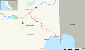
Map of northeastern California with SR 267 highlighted in red
Route information
Maintained by Caltrans
Length12.69 mi[1] (20.42 km)
Major junctions
West end I-80 / SR 89 in Truckee
East end SR 28 at Kings Beach
Location
CountryUnited States
StateCalifornia
CountiesNevada, Placer
Highway system
SR 266 SR 269

State Route 267 (SR 267), known as North Shore Boulevard, is a state highway in the U.S. state of California. It connects Interstate 80 in Truckee with State Route 28 in Kings Beach on Lake Tahoe's shoreline. It serves as an alternate route to State Route 89 for connecting between Interstate 80 and State Route 28 near the Nevada border. SR 267 also serves the Northstar California ski resort.

Route description

View east along SR 267 near Truckee Tahoe Airport during fog.

The route begins at Interstate 80 in Truckee with an interchange. It then continues through Nevada County until it reaches the county line. In Placer County, it meets its east end at SR 28 in Kings Beach.

SR 267 is not part of the National Highway System,[2] a network of highways that are considered essential to the country's economy, defense, and mobility by the Federal Highway Administration.[3] The route from I-80 to Brockway Road is named the CHP Officer Glenn Carlson Memorial Bypass after CHP officer Glenn W. Carlson, who was killed along the route in 1963.[4]

Major intersections

Except where prefixed with a letter, postmiles were measured on the road as it was in 1964, based on the alignment that existed at the time, and do not necessarily reflect current mileage. R reflects a realignment in the route since then, M indicates a second realignment, L refers to an overlap due to a correction or change, and T indicates postmiles classified as temporary (for a full list of prefixes, see California postmile § Official postmile definitions).[5] Segments that remain unconstructed or have been relinquished to local control may be omitted. The numbers reset at county lines; the start and end postmiles in each county are given in the county column.

CountyLocationPostmile
[5][1][6]
DestinationsNotes
Nevada
NEV M0.00-M1.80
TruckeeM0.00
SR 89 north – Sierraville
Continuation beyond I-80
M0.00
I-80 / SR 89 south – Reno, Sacramento
Interchange; west end of SR 267; I-80 east exit 188B, west exit 188
M1.42Brockway Road, Soaring WayBrockway Road is former SR 267
Placer
PLA 0.00-9.90
3.76Northstar Drive
Kings Beach9.90 SR 28 (Lake Boulevard) – Stateline, Tahoe CityEast end of SR 267
1.000 mi = 1.609 km; 1.000 km = 0.621 mi

See also

References

  1. ^ a b California Department of Transportation (July 2007). "Log of Bridges on State Highways". Sacramento: California Department of Transportation.
  2. ^ Federal Highway Administration (March 25, 2015). National Highway System: California (North) (PDF) (Map). Scale not given. Washington, DC: Federal Highway Administration. Retrieved September 3, 2017.
  3. ^ Natzke, Stefan; Neathery, Mike & Adderly, Kevin (June 20, 2012). "What is the National Highway System?". National Highway System. Washington, DC: Federal Highway Administration. Retrieved July 1, 2012.
  4. ^ California Department of Transportation; California State Transportation Agency (January 2021). 2020 Named Freeways, Highways, Structures and Other Appurtenances in California (PDF). Sacramento: California Department of Transportation. pp. 88, 240. Archived from the original (PDF) on October 10, 2022.
  5. ^ a b California Department of Transportation. "State Truck Route List". Sacramento: California Department of Transportation. Archived from the original (XLS file) on September 5, 2015. Retrieved June 30, 2015.
  6. ^ California Department of Transportation, All Traffic Volumes on CSHS, 2007
KML is from Wikidata