Bucketts Way

Bucketts Way

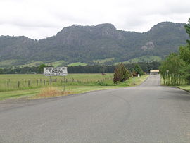
The Bucketts Range from Bucketts Way
Bucketts Way is located in New South Wales
North end
North end
South end
South end
Coordinates
General information
TypeRural road
Length151 km (94 mi)[1]
GazettedAugust 1928 (as Main Road 10)[2]
July 1952 (as Trunk Road 90)[3]
Route number(s) Tourist Route 2
Major junctions
North endManning River Drive
Purfleet, New South Wales
 Thunderbolts Way
South end Pacific Highway
Twelve Mile Creek, New South Wales
Location(s)
Major settlementsTinonee, Gloucester, Stroud

(The) Bucketts Way is a 151-kilometre (94 mi)[1] rural road that links Gloucester to Taree and Raymond Terrace, in New South Wales, Australia. A former alignment of Pacific Highway, it was later named after the Bucketts Mountains, a prominent mountain range near Gloucester. The entire route is designated as Tourist Route 2.[4]

Route

In the south, the Bucketts Way branches off to the west of Pacific Highway at Twelve Mile Creek, 14 km (9 mi) north of the Raymond Terrace bypass. Heading north, it crosses the Karuah River about 8.5 km (5.3 mi) south of Stroud and then roughly follows the course of the Karuah River upstream in a west-north-westerly direction for approximately 25 km (16 mi), crossing the Mammy Johnsons River. It then turns north-north-east and then north for 32 km (20 mi) until it reaches Gloucester, crossing the Avon River on the way. The North Coast railway line runs parallel with it from just north-east of Stroud Road to Gloucester. At Gloucester, Bucketts Way meets the southern terminus of Thunderbolts Way that leads to the Northern Tablelands and various other national parks and riverside camping reserves along the way. The Bucketts Way continues eastwards to Krambach, ending at the intersection with Manning River Drive in Purfleet just south of Taree, close to its interchange with Pacific Highway.

It provides access to the Barrington Tops National Park, and is used by tourists as a very scenic alternative to Pacific Highway. The Bucketts Way travels through two council areas: Port Stephens and Mid-Coast Council.

History

The passing of the Main Roads Act of 1924[5] through the Parliament of New South Wales provided for the declaration of Main Roads, roads partially funded by the State government through the Main Roads Board (MRB). North Coast Highway was declared (as Main Road No. 10) 8 August 1928 from Twelve Mile Creek to Purfleet (continuing southwards to Hexham, and northwards via Port Macquarie, Coffs Harbour, Ballina, Byron Bay and Murwillumbah to Tweed Heads.[2] With the passing of the Main Roads (Amendment) Act of 1929[6] to provide for additional declarations of State Highways and Trunk Roads, this was amended to State Highway 10 on 8 April 1929. North Coast Highway was renamed Pacific Highway (and extended south to North Sydney) on 26 May 1931.[7]

A new alignment of Pacific Highway was constructed between Twelve Mile Creek via Karuah, Bulahdelah and Nabiac to Purfleet; as a result, the former alignment via Stroud and Gloucester was re-declared as Trunk Road 90 on 30 July 1952.[3] Trunk Road 90 was officially named The Bucketts Way on 18 October 1972.[8]

The passing of the Roads Act of 1993[9] through the Parliament of New South Wales updated road classifications and the way they could be declared within New South Wales. Under this act, the northern end of Main Road 90 (formerly Trunk Road 90) was re-aligned from Krambach via Dyers Crossing to end at the intersection with Pacific Highway in Nabiac on 22 November 1996;[10] the southern end of Main Road 192 was extended to cover the former alignment between Burrell Creek and Krambach (and continuing north via Wingham to Taree),[10] with the road from Burrell Creek via Tinonee and Purfleet currently undeclared. Bucketts Way today, as parts of Main Roads 90 and 192, still retain these declarations.[11]

Some councillors of the former Gloucester Shire had proposed renaming the section of Bucketts Way south of Gloucester to Thunderbolts Way in December 2004,[12] as is shown on some tourist maps. This would result in one continuously named road stretching from Pacific Highway near Raymond Terrace to New England Highway at Uralla and beyond. However, there was significant community opposition to a name change.

Major junctions

LGALocationkm[1]miDestinationsNotes
Mid-CoastPurfleet0.00.0Manning River Drive – Taree, Wingham
to Pacific Highway (A1) – Port Macquarie, Raymond Terrace, Newcastle, Sydney
Northern terminus of Bucketts Way and Tourist Route 2 at roundabout
Burrell Creek17.911.1Gloucester Road – Wingham, Taree
Krambach34.021.1Mill Street, to Avalon Road – Nabiac
Gangat56.835.3Wallanbah Road – Wallanbah, Bucca Wauka
Avon River69.042.9Bridge over the river (Bridge name unknown)
GloucesterGloucester69.843.4North Coast railway line
70.643.9Thunderbolts Way – Walcha, Uralla, InverellRoundabout
74.046.0Jacks Road, to Waukivory Road – Upper Mayall, Bulahdelah
80.149.8Gloucester Tops Road – Barrington Tops National Park
Avon River83.651.9Bridge over the river (Bridge name unknown)
Mid-CoastStroud Road111.869.5North Coast railway line
Mammy Johnsons River112.569.9Bridge over the river (Bridge name unknown)
Mid-CoastStroud116.272.2Stroud Hill Road – Dungog
Booral127.179.0Booral Road – Bulahdelah
Karuah River128.379.7Bridge over the river (Bridge name unknown)
Mid-CoastLimeburners Creek135.384.1Limeburners Creek Road – Clarence Town
Port StephensTwelve Mile Creek150.693.6 Pacific Highway (A1) – Port Macquarie, Raymond Terrace, Newcastle, SydneySouthern terminus of Bucketts Way and Tourist Route 2
1.000 mi = 1.609 km; 1.000 km = 0.621 mi
  •       Route transition

See also

References

  1. ^ a b c "The Bucketts Way" (Map). Google Maps. Retrieved 7 December 2022.
  2. ^ a b "Main Roads Act, 1924-1927". Government Gazette of the State of New South Wales. No. 110. National Library of Australia. 17 August 1928. pp. 3814–20. Retrieved 1 August 2022.
  3. ^ a b "Main Roads Act, 1924-1951". Government Gazette of the State of New South Wales. No. 167. National Library of Australia. 22 August 1952. p. 3044. Archived from the original on 19 September 2022. Retrieved 7 December 2022.
  4. ^ "Tourist Drive 2 - Bucketts Way". Destination NSW. Government of New South Wales. Retrieved 10 December 2021.
  5. ^ State of New South Wales, An Act to provide for the better construction, maintenance, and financing of main roads; to provide for developmental roads; to constitute a Main Roads Board Archived 11 August 2022 at the Wayback Machine 10 November 1924
  6. ^ State of New South Wales, An Act to amend the Main Roads Act, 1924-1927; to confer certain further powers upon the MRB; to amend the Local Government Act, 1919, and certain other Acts; to validate certain payments and other matters; and for purposes connected therewith. Archived 12 August 2022 at the Wayback Machine 8 April 1929
  7. ^ "Main Roads Act, 1924-1929". Government Gazette of the State of New South Wales. No. 65. National Library of Australia. 29 May 1931. p. 1875. Archived from the original on 19 September 2022. Retrieved 19 September 2022.
  8. ^ "Main Roads Act, 1924". Government Gazette of the State of New South Wales. No. 117. National Library of Australia. 3 November 1972. p. 4340. Archived from the original on 19 September 2022. Retrieved 7 December 2022.
  9. ^ State of New South Wales, An Act to make provision with respect to the roads of New South Wales; to repeal the State Roads Act 1986, the Crown and Other Roads Act 1990 and certain other enactments; and for other purposes. Archived 11 August 2022 at the Wayback Machine 10 November 1924
  10. ^ a b "Roads Act". Government Gazette of the State of New South Wales. No. 134. National Library of Australia. 22 November 1996. pp. 7657–62. Archived from the original on 13 October 2022. Retrieved 13 October 2022.
  11. ^ Transport for NSW (August 2022). "Schedule of Classified Roads and Unclassified Regional Roads" (PDF). Government of New South Wales. Archived from the original (PDF) on 25 August 2022. Retrieved 1 August 2022.
  12. ^ "Bucketts Way - Road Re-Naming" (PDF). Great Lakes Council. Archived from the original (PDF) on 24 September 2009. Retrieved 3 October 2009.