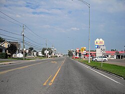
City in Quebec, Canada
Berthierville (;[ 4] French pronunciation: [bɛʁtjevil] Berthier-en-haut , and legally called Berthier before 1942) is a town located between Montreal and Trois-Rivières on the north shore of the Saint Lawrence River in Quebec , Canada. Berthierville is the seat of D'Autray Regional County Municipality , and is served by Autoroute 40 , and is the junction of Routes 138 and 158 . It is surrounded by the parish municipality of Sainte-Geneviève-de-Berthier .
The Marie Reine du Canada PilgrimageLanoraie to Cap-de-la-Madeleine .
Sainte-Geneviève de Berthierville church, opened 22 August 1787.
Demographics
In the 2021 Census of Population conducted by Statistics Canada , Berthierville had a population of 2 (2.61 sq mi), it had a population density of 2 (1,677.9/sq mi) in 2021.[ 5]
Population trend:[ 6]
Population in 2011: 4091 (2006 to 2011 population change: 2.1%)
Population in 2006: 4007
Population in 2001: 3939
Population in 1996: 3952
Population in 1991: 3854 Mother tongue:
English as first language: 0.3%
French as first language: 96.5%
English and French as first language: 0.3%
Other as first language: 3.0%
Education
This section
needs expansion . You can help by
adding to it .
(September 2017 )
Centre de services scolaire des Samares , formerly the Commission scolaire des Samares, operates francophone public schools, including:
The Sir Wilfrid Laurier School Board operates anglophone public schools, including:
Notable people
See also
References
^ "Banque de noms de lieux du Québec : Reference number 5375" . toponymie.gouv.qc.ca (in French). Commission de toponymie du Québec .^ a b "Répertoire des municipalités : Geographic code 52035" . www.mamh.gouv.qc.ca (in French). Ministère des Affaires municipales et de l'Habitation.^ a b Statistics Canada 2011 Census - Berthierville census profile
^ The Canadian Press (2017), The Canadian Press Stylebook (18th ed.), Toronto: The Canadian Press ^ "Population and dwelling counts: Canada, provinces and territories, and census subdivisions (municipalities), Quebec" . Statistics Canada . February 9, 2022. Retrieved August 29, 2022 .^ Statistics Canada: 1996 , 2001 , 2006 , 2011 census
^ "du Chemin-du-Roy (pavillon maternelle Sainte-Geneviève) Archived 2017-09-22 at the Wayback Machine ." Commission scolaire des Samares . Retrieved on September 22, 2017.
^ "du Chemin-du-Roy (pavillon Sainte-Geneviève) Archived 2017-09-22 at the Wayback Machine ." Commission scolaire des Samares . Retrieved on September 22, 2017.
^ "du Chemin-du-Roy (pavillon Saint-Joseph) Archived 2017-09-22 at the Wayback Machine ." Commission scolaire des Samares . Retrieved on September 22, 2017.
^ "École de l'Île Saint-Ignace Archived 2017-09-22 at the Wayback Machine ." Commission scolaire des Samares . Retrieved on September 22, 2017.
^ "JOLIETTE ELEMENTARY ZONE Archived 2017-09-17 at the Wayback Machine ." Sir Wilfrid Laurier School Board . Retrieved on September 17, 2017.
^ "Joliette High School Zone Sec 1-5 Archived 2017-09-04 at the Wayback Machine ." Sir Wilfrid Laurier School Board . Retrieved on September 5, 2017.
External links
Adjacent Municipal Subdivisions
Cities & towns Municipalities Parishes
Arranged west to east; termini in italics


