|
Ban Phai district
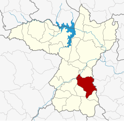
Ban Phai (Thai: บ้านไผ่, pronounced [bâːn pʰàj]; Northeastern Thai: บ้านไผ่, pronounced [bâːn pʰāj]) is a district (amphoe) of Khon Kaen province, northeastern Thailand. GeographyNeighboring districts are (from the south clockwise): Pueai Noi, Nong Song Hong, Non Sila, Chonnabot, Mancha Khiri, and Ban Haet of Khon Kaen Province; Kosum Phisai and Kut Rang of Maha Sarakham province. HistoryOriginally named Ban Keng (บ้านเกิ้ง), the area was at first a subdistrict (tambon) of Chonnabot district. In 1928 the minor district (king amphoe) Ban Phai was established consisting of three subdistricts split off from Chonnabot.[1] It was upgraded to a full district on 1 February 1940.[2] In 1946 Chonnabot was downgraded to be a part of Ban Phai District, until it was reestablished in 1966. EconomyAs of 2019[update], Thai sugar giant, the Mitr Phol Group, plans to construct a sugarcane mill and biomass power plant in the district. The initiative will occupy 4,000 rai (640 ha; 1,600 acres) of three of the province's neighbouring districts: Ban Phai, Chonnabot, and Non Sila. The operation will form part of the Ban Phai Bio-Hub Industrial Estate and is linked to the Eastern Economic Corridor (EEC) project. Mitr Phol's plans have been met with some opposition from local residents.[3] Mitr Phol has pledged that the factory will have no adverse environmental effects.[4] AdministrationThe district is divided into 10 subdistricts (tambons), which are further subdivided into 113 villages (mubans). Ban Phai is a town (thesaban mueang) which covers parts of tambons Ban Phai, Khaen Nuea, and Nai Mueang. There are a further 10 tambon administrative organizations (TAO).
Missing numbers are subdistricts which now form Ban Haet and Non Sila Districts. References
External links
|
|||||||||||||||||||||||||||||||||||||||||||||||||||||||||||||||||||||||||||||||||||||||||||||
