|
Ban Maet
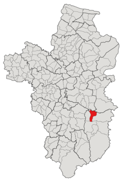
Ban Maet (Thai: บ้านแมด) is a tambon (subdistrict) located in the northwestern region of Buntharik district, in Ubon Ratchathani Province, Thailand.[1][2][3] In 2021, it had a population of 8,542 people.[1] Neighbouring subdistricts are (clockwise from the south) Nong Sano, Na Pho, Non Kalong, Non Ko, and Kho Laen.[4] HistoryPreviously, Ban Maet was a small village located on the left bank of Huay Dod Creek (ห้วยโดด), one of the tributaries of the Lam Dom Noi River, and was governed by Kho Laen.[2] Later in 1973, it was separated from Kho Laen to form a new subdivision, Na Pho, with seven other villages.[2][5] Due to deforestation, the steam levels of the four water creeks in the area, including Huay Dod, Huay Thalaeng, Huay Thaen, and Huay Kham, were drastically decreased. As a result, people began to conquer the formerly flooded land and establish more communities,[2] including the Ban Maet village, which increased in population and eventually gained subdistrict status in 1987 by absorbing six other settlements in the Na Pho subdistrict's eastern half.[2][3] After its establishment, tambon (subdistrict) Ban Maet was governed by the subdistrict council, which was later promoted to the Subdistrict Administrative Organization (SAO) in 1996.[2] GeographyThe tambon covers 96 km2 and is located in the northwestern region of the Buntharik district, on the Lam Dom Noi river basins.[4] AdministrationThe subdistrict of Ban Maet is divided into 12 villages (mubans; หมู่บ้าน).[1][4] As of the 2021 census, it had a population of 8,542 people with 2,479 households.[1] Since 1996, the Subdistrict Administrative Organization of Ban Maet (องค์การบริหารส่วนตำบลบ้านแมด; Ban Maet SAO) has been the local government responding to administer the area.[1][2][4] The following is a list of the subdistrict's mubans, which roughly correspond to the villages.[1]
References
|
|||||||||||||||||||||||||||||||||||||||||||||||||||||||||||||||||||||||||||||||||||||||||||||||||||||||||||||
