Angustura, New Mexico

Angustura, New Mexico
Angustura is located in New Mexico
Angustura
Angustura
Angustura is located in the United States
Angustura
Angustura
Coordinates: 36°42′50″N 107°54′56″W / 36.71389°N 107.91556°W / 36.71389; -107.91556
CountryUnited States
StateNew Mexico
CountySan Juan
Area
 • Total
4.85 sq mi (12.56 km2)
 • Land4.77 sq mi (12.36 km2)
 • Water0.08 sq mi (0.20 km2)
Elevation5,506 ft (1,678 m)
Population
 • Total
1,407
 • Density294.91/sq mi (113.87/km2)
Time zoneUTC-7 (Mountain (MST))
 • Summer (DST)UTC-6 (MDT)
ZIP Code
87413 (Bloomfield)
Area code505
FIPS code35-03680
GNIS feature ID2806747[2]

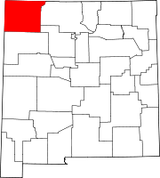
Angustura is an unincorporated community and census-designated place (CDP) in San Juan County, New Mexico, United States. It was first listed as a CDP prior to the 2020 census.[2]

The CDP is in the northeast part of the county, bordered to the west by the city of Bloomfield and to the east by Blanco. The San Juan River forms the southern border of the community. U.S. Route 64 passes through Angustura, leading west through Bloomfield 17 miles (27 km) to Farmington and east 67 miles (108 km) to Dulce.

Demographics

Historical population
CensusPop.Note
20201,407
U.S. Decennial Census[4][3]

Education

The area school district is Bloomfield Schools.[5] Bloomfield High School is the local high school.

References

  1. ^ "ArcGIS REST Services Directory". United States Census Bureau. Retrieved October 12, 2022.
  2. ^ a b c "Angustura Census Designated Place". Geographic Names Information System. United States Geological Survey, United States Department of the Interior.
  3. ^ a b "Census Population API". United States Census Bureau. Retrieved October 12, 2022.
  4. ^ "Census of Population and Housing". Census.gov. Retrieved June 4, 2016.
  5. ^ "2020 CENSUS - SCHOOL DISTRICT REFERENCE MAP: San Juan County, NM" (PDF). U.S. Census Bureau. Retrieved July 12, 2022.