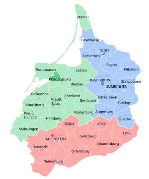
Governmental district of East Prussia from 1905 to 1945
East Prussian Regierungsbezirk Allenstein (red), established in 1905 Regierungsbezirk Allenstein was a Regierungsbezirk Prussian province of East Prussia from 1905 until 1945. The regional capital was Allenstein (present-day Olsztyn). The territory today is part of the Polish Warmian-Masurian Voivodeship .
History
The government region was created on 1 November 1905 as the third East Prussian Regierungsbezirk out of the southern districts of the two original administrative regions Gumbinnen and Königsberg , which had been established in 1815. It comprised the south of the former Duchy of Prussia ; the lands of the Allenstein and Rößel districts had belonged to the Prince-Bishopric of Warmia , annexed by Prussia in 1772. In the 1920 East Prussian plebiscite all the Allenstein Region plus the District of Oletzko [de ] was part of the Allenstein Plebiscite precinct, with the electorate voting for remaining with Germany by more than 97%.
In 1945 following World War II , Regierungsbezirk Allenstein was dissolved when East Prussia was partitioned between the Republic of Poland and the Soviet Union (Kaliningrad Oblast) according to the resolutions at the Potsdam Conference .
Demographics
The Allenstein region was ethnically mixed in 1910, with German , Polish and Masurian speakers.
Ethnolinguistic structure in Regierungsbezirk Allenstein (1910 census)[ 1]
1910 census
Population
German
Masurian
Polish
Bilingual
Allenstein Region
543,469
274,320
50.48%
175,016
32.20%
73,154
13.46%
19,532
3.59%
Allenstein Urban
33,077
29,344
88.71%
99
0.30%
2,249
6.80%
1,325
4.01%
Allenstein Rural
57,919
22,825
39.41%
520
0.90%
32,766
56.57%
1,782
3.08%
Johannisburg
51,399
16,379
31.87%
29,141
56.70%
4,203
8.18%
1,620
3.15%
Lötzen
41,209
26,352
63.95%
11,412
27.69%
1,595
3.87%
1,802
4.37%
Lyck
55,579
27,138
48.83%
19,407
34.92%
6,348
11.42%
2,590
4.66%
Neidenburg
59,416
20,871
35.13%
25,150
42.33%
10,462
17.61%
2,645
4.45%
Ortelsburg
69,935
20,218
28.91%
43,513
62.22%
3,390
4.85%
2,463
3.52%
Osterode
74,666
43,508
58.27%
26,695
35.75%
2,130
2.85%
2,279
3.05%
Rössel
50,472
43,189
85.57%
48
0.10%
6,512
12.90%
723
1.42%
Sensburg
50,097
24,496
48.90%
19,031
37.99%
3,499
6.98%
2,310
4.61%
Districts
District office in Allenstein As of 31 December 1937:
District
Capital (present name)
Area
Population
Allenstein, urban district
(Olsztyn ) 52 km2 (20 sq mi)
46,513 (1939)
Allenstein, rural district [de ] Allenstein (Olsztyn )
1,302.58 km2 (502.93 sq mi)
57,077 (1939)
Johannisburg [de ] Johannisburg in East Prussia (Pisz ) [ 2]
1,684 km2 (650 sq mi)
52,672 (1939)
Lötzen [de ] Lötzen (Giżycko ) [ 3]
898.8 km2 (347.0 sq mi)
47,681 (1939)
Lyck [de ] Lyck (Ełk )
1,114 km2 (430 sq mi)
56,129 (1939)
Neidenburg [de ] Neidenburg (Nidzica ) [ 4]
1,157 km2 (447 sq mi)
39,486 (1939)
Ortelsburg [de ] Ortelsburg (Szczytno )
1,703 km2 (658 sq mi)
72,146 (1939)
Osterode in East Prussia [de ] Osterode in East Prussia (Ostróda )
1,551 km2 (599 sq mi)
75,879 (1939)
Rößel [de ] Bischofsburg (Biskupiec )
853 km2 (329 sq mi)
51,086 (1939)
Sensburg [de ] Sensburg (Mrągowo ) [ 5]
1,234 km2 (476 sq mi)
52,746 (1939)
total
Allenstein
11,547 km2 (4,458 sq mi)
568,024
Notes
53°45′N 20°30′E / 53.75°N 20.5°E / 53.75; 20.5

