Al-Kfeir

Al-Kfeir
الكفير
Municipality
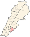
Map showing the location of Al-Kfeir within Lebanon
Al-Kfeir
Location within Lebanon
Coordinates: 33°25′46″N 35°44′26″E / 33.42944°N 35.74056°E / 33.42944; 35.74056
Country Lebanon
GovernorateNabatieh Governorate
DistrictHasbaya District
Elevation
900 m (3,000 ft)
Time zoneUTC+2 (EET)
 • Summer (DST)UTC+3 (EEST)
Dialing code+961

Al-Kfeir (Arabic: الكفير) is a municipality nestled 900 m above sea level, in Hasbaiya District (Qada'a), an administrative division of Nabatiyeh Governorate (Mohafazah) along the steep slopes of the top of the Jebel Sheikh in Lebanon.

The village enjoys mild summers of an average temperature of 25°C. However, the winters are much colder and the village receives heavy snow.

The inhabitants of Al-Kfeir are predominatly Greek Orthodox and Druze,[1] and they mainly cultivate olives, pines and other fruit trees.

Demographics

In 2014 Christians made up 50.61% and Druze made up 48.38% of registered voters in Al-Kfeir. 43.09% of the voters were and Greek Orthodox.[2]

Notable people

References

  1. ^ "التوزيع حسب المذاهب للناخبين/ناخبات في بلدة الكفير، قضاء حاصبيا محافظة النبطية في لبنان". إعْرَفْ لبنان. Retrieved 2024-10-31.
  2. ^ https://lub-anan.com/المحافظات/النبطية/حاصبيا/الكفير/المذاهب/
  3. ^ "Lebanon independents celebrate: 'change has begun'". France 24. 2022-05-19. Retrieved 2023-04-16.
  4. ^ Khzam, Ruba Bou (2022-05-18). "Firas Hamdan, From A Wounded Revolutionary In Front Of Parliament To An MP Inside It". 961. Retrieved 2023-04-16.

Sources