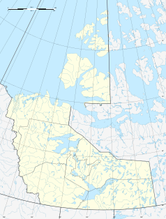
| Fort Good Hope
|
| Lage in Kanada
|
 Fort Good Hope (Nordwest-Territorien) Fort Good Hope (Nordwest-Territorien) |
|
| Staat:
|
Kanada Kanada Kanada
|
| Territorium:
|
Nordwest-Territorien
|
| Region:
|
Sahtu
|
| Koordinaten:
|
66° 15′ N, 128° 38′ W66.256944444444-128.63777777778Koordinaten: 66° 15′ N, 128° 38′ W
|
| Einwohner:
|
516 (Stand: 2016[1])
|

Fort Good Hope und Mackenziefluss
|
Fort Good Hope, Bezirk Sahtu, Nordwest-Territorien, Kanada, ist eine von 516 Menschen (Stand 2016) bewohnte Siedlung.
Lage
Ford Good Hope liegt am 1903 km langen Mackenziefluss, der sich, vom Großen Sklavensee kommend, in das Arktische Eismeer ergießt.[2] Der schwer erreichbare Ort verfügt über einen Landeplatz und wird regelmäßig von den Fluglinien Canadian North und Buffalo Airways angeflogen.
Sonstiges
- Kurz vor Weihnachten 2009 brannte der Dorfladen "Northern store" ab.[3]
Einwohnerentwicklung
| Jahr |
Einwohnerzahl[4] |
Veränderung in %
|
| 1996 |
699 |
–
|
| 1997 |
687 |
−1,7 %
|
| 1998 |
674 |
−1,9 %
|
| 1999 |
642 |
−4,7 %
|
| 2000 |
607 |
−5,5 %
|
| 2001 |
586 |
−3,5 %
|
| 2002 |
596 |
1,7 %
|
| 2003 |
566 |
−5,0 %
|
| 2004 |
553 |
−2,3 %
|
| 2005 |
558 |
0,9 %
|
| 2006 |
576 |
3,2 %
|
| 2007 |
575 |
−0,2 %
|
| 2008 |
564 |
−1,9 %
|
| 2009 |
567 |
0,5 %
|
Persönlichkeiten
Weblinks
Einzelnachweise
- ↑ Statistics Canada: Population and dwelling counts, for Northwest Territories and census subdivisions (municipalities), 2016 and 2011 censuses, abgerufen am 2. Mai 2021
- ↑ Luftaufnahme (Memento des Originals vom 15. April 2006 im Internet Archive)
 Info: Der Archivlink wurde automatisch eingesetzt und noch nicht geprüft. Bitte prüfe Original- und Archivlink gemäß Anleitung und entferne dann diesen Hinweis.@1@2Vorlage:Webachiv/IABot/www.maca.gov.nt.ca
- ↑ http://www.cbc.ca/news/canada/north/story/2009/12/15/fgh-northern-store-fire.html fgh-northern-store-fire
- ↑ Fort Good Hope - Statistical Profile (Memento vom 30. September 2011 im Internet Archive)

