Chrbonín

Chrbonín
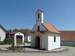
Chapel of the Assumption of the Virgin Mary
Bendera Chrbonín
Lambang kebesaran Chrbonín
Chrbonín di Czech Republic
Chrbonín
Chrbonín
Location in the Czech Republic
Koordinat: 49°21′31″N 14°51′52″E / 49.35861°N 14.86444°E / 49.35861; 14.86444
Country Ceko
RegionSouth Bohemian
DistrictTábor
First mentioned1379
Luas
 • Total7,09 km2 (274 sq mi)
Ketinggian
588 m (1,929 ft)
Populasi
 (2022-01-01)[1]
 • Total157
 • Kepadatan0,22/km2 (0,57/sq mi)
Zona waktuUTC+1 (CET)
 • Musim panas (DST)UTC+2 (CEST)
Postal code
391 55
Situs webobec-chrbonin.cz

Chrboní adalah kotamadya dan desa di Distrik Tábor di Wilayah Bohemia Selatan di Republik Ceko. Ini memiliki sekitar 200 penduduk.

Referensi

A PHP Error was encountered

Severity: Notice

Message: Trying to get property of non-object

Filename: wikipedia/wikipediareadmore.php

Line Number: 5

A PHP Error was encountered

Severity: Notice

Message: Trying to get property of non-object

Filename: wikipedia/wikipediareadmore.php

Line Number: 70
 

A PHP Error was encountered

Severity: Notice

Message: Undefined index: HTTP_REFERER

Filename: controllers/ensiklopedia.php

Line Number: 41