|
TF postcode area
Postcode area within the United Kingdom
KML is from Wikidata Postcode area in United Kingdom
The TF postcode area, also known as the Telford postcode area,[2] is a group of thirteen postcode districts in England, within six post towns. These cover north-east Shropshire, including Telford, Broseley, Market Drayton, Much Wenlock, Newport and Shifnal, plus a small part of west Staffordshire.
Coverage
The approximate coverage of the postcode districts:
| Postcode district
|
Post town
|
Coverage
|
Local authority area(s)
|
| TF1
|
TELFORD
|
Wellington, Leegomery, Hadley, Ketley, Arleston, Hortonwood
|
Telford & Wrekin
|
| TF2
|
TELFORD
|
Oakengates, Priorslee, St. Georges, Donnington, Wrockwardine Wood, Muxton
|
Telford & Wrekin
|
| TF3
|
TELFORD
|
Telford Town Centre and Park, Hollinswood, Randlay, Stirchley, Brookside, Stafford Park
|
Telford & Wrekin
|
| TF4
|
TELFORD
|
Dawley, Malinslee, Lawley, Horsehay
|
Telford & Wrekin
|
| TF5
|
TELFORD
|
Admaston, Bratton, Shawbirch
|
Telford & Wrekin
|
| TF6
|
TELFORD
|
The Wrekin, Wrockwardine, Longden-upon-Tern, High Ercall
|
Telford & Wrekin
|
| TF7
|
TELFORD
|
Madeley, Woodside, Sutton Hill, Halesfield
|
Telford & Wrekin
|
| TF8
|
TELFORD
|
Ironbridge, Coalbrookdale, Coalport, Jackfield
|
Telford & Wrekin
|
| TF9
|
MARKET DRAYTON
|
Market Drayton, Loggerheads, Hodnet, Ternhill
|
Shropshire, Newcastle-under-Lyme
|
| TF10
|
NEWPORT
|
Newport, Lilleshall, Edgmond, Moreton, Great Chatwell, Orslow
|
Telford & Wrekin, Stafford, South Staffordshire
|
| TF11
|
SHIFNAL
|
Shifnal, Tong, Weston-under-Lizard
|
Shropshire, South Staffordshire
|
| TF12
|
BROSELEY
|
Broseley
|
Shropshire
|
| TF13
|
MUCH WENLOCK
|
Much Wenlock
|
Shropshire
|
Map
KML is from Wikidata
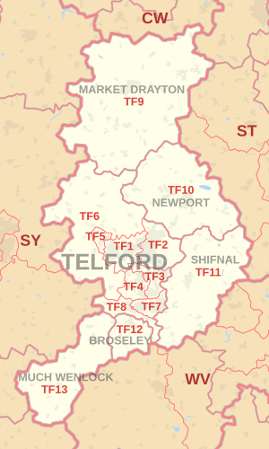 TF postcode area map, showing postcode districts in red and post towns in grey text, with links to nearby CW, ST, SY and WV postcode areas. TF postcode area map, showing postcode districts in red and post towns in grey text, with links to nearby CW, ST, SY and WV postcode areas.
See also
References
External links
|
|---|
| | Crown dependencies | |
|---|
| Overseas territories | |
|---|
| Non-geographic | |
|---|
|
|
|

